Cottonwood Falls geodata
Cottonwood Falls (Kansas) is a seat of a second-order administrative division; located in United States in America/Chicago (GMT-5) time zone. With population of 872 people, there are 17174 cities with bigger population in this country. Compared to other cities in United States, 59.5% of cities are located further ↑North; 74.6% of cities are located further →East and 81.7% of cities have lower elevation than Cottonwood Falls. Note1


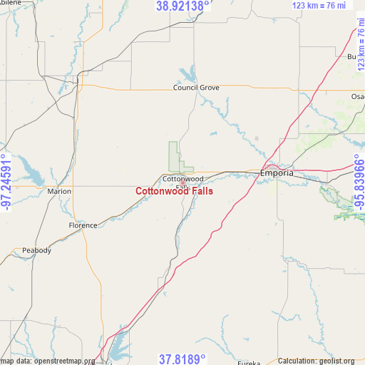
Cottonwood Falls GPS coordinates[2]
38° 22' 20.064" North, 96° 32' 34.008" West
| Map corner | latitude | longitude |
|---|---|---|
| Upper-left | 38.92138°, | -97.24591° |
| Center: | 38.37224°, | -96.54278° |
| Lower-right: | 37.8189°, | -95.83966° |
| Map W x H: | 122.6×122.6 km | = 76.2×76.2mi |
| max Lat: | 71.29058° ⇑59.5% North |
| Cottonwood Falls: | 38.37224° |
| min Lat: | ⇓40.5% South 19.06759° |
| min Long | Cottonwood Fall | max Long |
| -171.73463° | -96.54278° | -66.98998° |
| W 25.4%⇐ | ⇒74.6% E |
Elevation
Elevation of Cottonwood Falls is 373 m = 1224 ft, and this is 78.2 m = 257 ft above average elevation for this country.
| Max E: |
3189 m = 10463 ft | 18.3% |
| Cottonwood Falls | 373 m 1224 ft | |
| Avg. | 294.8 m = 967 ft | |
Min E: |
-60 m = -197 ft | 81.7% |
See also: United States elevation on elevation.city.
Geographical zone
Cottonwood Falls is located in North temperate zone (between Tropic of Cancer and the Arctic Circle). Distance of this Northern Tropic circle is 1660.7 km =1031.9 mi to South.| Distance of | km | miles | from Cottonwood Falls |
|---|---|---|---|
| North Pole | 5740.5 | 3567 | to North |
| Arctic Circle | 3134.6 | 1947.7 | to North |
| Tropic Cancer | 1660.7 | 1031.9 | to South |
| Equator | 4266.6 | 2651.1 | to South |


Nearby cities:
15 places around Cottonwood Falls: (largest is in red/bold)
• Americus
28.7 km =17.8 mi,  58°
58°
• Council Grove
32.4 km =20.1 mi,  7°
7°
• El Dorado
67.7 km =42.1 mi,  204°
204°
• Emporia
31.7 km =19.7 mi,  83°
83°
• Eskridge
65.9 km =40.9 mi,  34°
34°
• Eureka
64.9 km =40.3 mi,  159°
159°
• Herington
48.1 km =29.9 mi,  313°
313°
• Hillsboro
57.7 km =35.9 mi,  267°
267°
• Lebo
60.3 km =37.5 mi,  85°
85°
• Madison
44.2 km =27.5 mi,  126°
126°
• Marion
41.5 km =25.8 mi, 266°
• Olpe
35 km =21.7 mi,  110°
110°
• Osage City
68.8 km =42.8 mi, 64°
• Peabody
54.1 km =33.6 mi,  245°
245°
• White City
50 km =31.1 mi,  340°
340°
Sources, notices
• [Note1] Compared only with cities in United States existing in our database
• [Src1] Map data: © OpenStreetMap contributors (CC-BY-SA)
• [Src2] Other city data from geonames.org with taken over terms of usage.
• [Src3] Geographical zone / Annual Mean Temperature by Robert A. Rohde @ Wikipedia
