WaKeeney geodata
WaKeeney (Kansas) is a seat of a second-order administrative division; located in United States in America/Chicago (GMT-5) time zone. With population of 1,811 people, there are 12502 cities with bigger population in this country. Compared to other cities in United States, 54.6% of cities are located further ↑North; 80.7% of cities are located further →East and 91.5% of cities have lower elevation than WaKeeney. Note1


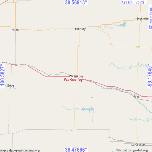
WaKeeney GPS coordinates[2]
39° 1' 30.036" North, 99° 52' 46.452" West
| Map corner | latitude | longitude |
|---|---|---|
| Upper-left | 39.56913°, | -100.5827° |
| Center: | 39.02501°, | -99.87957° |
| Lower-right: | 38.47666°, | -99.17645° |
| Map W x H: | 121.5×121.5 km | = 75.5×75.5mi |
| max Lat: | 71.29058° ⇑54.6% North |
| WaKeeney: | 39.02501° |
| min Lat: | ⇓45.4% South 19.06759° |
| min Long | WaKeeney | max Long |
| -171.73463° | -99.87957° | -66.98998° |
| W 19.3%⇐ | ⇒80.7% E |
Elevation
Elevation of WaKeeney is 754 m = 2474 ft, and this is 459.2 m = 1507 ft above average elevation for this country.
| Max E: |
3189 m = 10463 ft | 8.5% |
| WaKeeney | 754 m 2474 ft | |
| Avg. | 294.8 m = 967 ft | |
Min E: |
-60 m = -197 ft | 91.5% |
See also: United States elevation on elevation.city.
Geographical zone
WaKeeney is located in North temperate zone (between Tropic of Cancer and the Arctic Circle). Distance of this Northern Tropic circle is 1733.3 km =1077 mi to South.| Distance of | km | miles | from WaKeeney |
|---|---|---|---|
| North Pole | 5667.9 | 3521.9 | to North |
| Arctic Circle | 3062 | 1902.6 | to North |
| Tropic Cancer | 1733.3 | 1077 | to South |
| Equator | 4339.2 | 2696.3 | to South |


Nearby cities:
15 places around WaKeeney: (largest is in red/bold)
• Dighton
79 km =49.1 mi,  220°
220°
• Ellis
29.2 km =18.1 mi,  109°
109°
• Gove
53.2 km =33.1 mi,  261°
261°
• Hays
50.5 km =31.4 mi, 108°
• Hill City
37.9 km =23.5 mi,  4°
4°
• Hoxie
60.9 km =37.8 mi,  307°
307°
• La Crosse
73.9 km =45.9 mi,  137°
137°
• Logan
75.6 km =47 mi,  20°
20°
• Ness City
63.7 km =39.6 mi,  182°
182°
• Oakley
85.8 km =53.3 mi,  278°
278°
• Plainville
55.3 km =34.4 mi,  65°
65°
• Quinter
30.9 km =19.2 mi, 279°
• Russell
89.2 km =55.4 mi,  99°
99°
• Stockton
70.1 km =43.6 mi,  49°
49°
• Victoria
66.1 km =41.1 mi, 106°
Sources, notices
• [Note1] Compared only with cities in United States existing in our database
• [Src1] Map data: © OpenStreetMap contributors (CC-BY-SA)
• [Src2] Other city data from geonames.org with taken over terms of usage.
• [Src3] Geographical zone / Annual Mean Temperature by Robert A. Rohde @ Wikipedia
