Spring Hill geodata
Spring Hill (Kansas) is a populated place; located in United States in America/Chicago (GMT-5) time zone. With population of 5,981 people, there are 6419 cities with bigger population in this country. Compared to other cities in United States, 57% of cities are located further ↑North; 70.7% of cities are located further →East and 77.4% of cities have lower elevation than Spring Hill. Note1


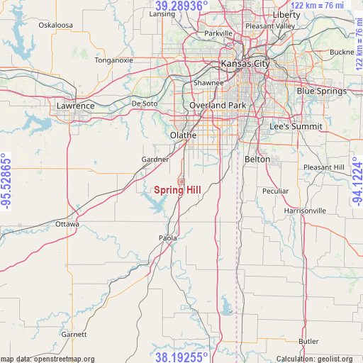
Spring Hill GPS coordinates[2]
38° 44' 35.016" North, 94° 49' 31.872" West
| Map corner | latitude | longitude |
|---|---|---|
| Upper-left | 39.28936°, | -95.52865° |
| Center: | 38.74306°, | -94.82552° |
| Lower-right: | 38.19255°, | -94.1224° |
| Map W x H: | 122×122 km | = 75.8×75.8mi |
| max Lat: | 71.29058° ⇑57% North |
| Spring Hill: | 38.74306° |
| min Lat: | ⇓43% South 19.06759° |
| min Long | Spring Hill | max Long |
| -171.73463° | -94.82552° | -66.98998° |
| W 29.3%⇐ | ⇒70.7% E |
Elevation
Elevation of Spring Hill is 331 m = 1086 ft, and this is 36.2 m = 119 ft above average elevation for this country.
| Max E: |
3189 m = 10463 ft | 22.6% |
| Spring Hill | 331 m 1086 ft | |
| Avg. | 294.8 m = 967 ft | |
Min E: |
-60 m = -197 ft | 77.4% |
See also: United States elevation on elevation.city.
Geographical zone
Spring Hill is located in North temperate zone (between Tropic of Cancer and the Arctic Circle). Distance of this Northern Tropic circle is 1701.9 km =1057.5 mi to South.| Distance of | km | miles | from Spring Hill |
|---|---|---|---|
| North Pole | 5699.2 | 3541.3 | to North |
| Arctic Circle | 3093.3 | 1922.1 | to North |
| Tropic Cancer | 1701.9 | 1057.5 | to South |
| Equator | 4307.8 | 2676.7 | to South |


Nearby cities:
15 places around Spring Hill: (largest is in red/bold)
• Belton
26.6 km =16.5 mi,  73°
73°
• Cleveland
21.3 km =13.2 mi,  109°
109°
• De Soto
29 km =18 mi,  334°
334°
• Edgerton
16 km =9.9 mi,  278°
278°
• Gardner
11.6 km =7.2 mi,  310°
310°
• Grandview
29.9 km =18.6 mi,  57°
57°
• Lenexa
24.7 km =15.3 mi,  18°
18°
• Loch Lloyd
22 km =13.7 mi, 63°
• Louisburg
18.6 km =11.6 mi,  137°
137°
• New Century, KS
10.9 km =6.8 mi,  323°
323°
• Olathe
15.4 km =9.6 mi,  2°
2°
• Osawatomie
29.4 km =18.3 mi,  201°
201°
• Overland Park
29.8 km =18.5 mi,  26°
26°
• Paola
19.6 km =12.2 mi,  193°
193°
• Wellsville
22.4 km =13.9 mi,  262°
262°
Sources, notices
• [Note1] Compared only with cities in United States existing in our database
• [Src1] Map data: © OpenStreetMap contributors (CC-BY-SA)
• [Src2] Other city data from geonames.org with taken over terms of usage.
• [Src3] Geographical zone / Annual Mean Temperature by Robert A. Rohde @ Wikipedia
