Dighton geodata
Dighton (Kansas) is a seat of a second-order administrative division; located in United States in America/Chicago (GMT-5) time zone. With population of 990 people, there are 16344 cities with bigger population in this country. Compared to other cities in United States, 58.9% of cities are located further ↑North; 81% of cities are located further →East and 92.4% of cities have lower elevation than Dighton. Note1


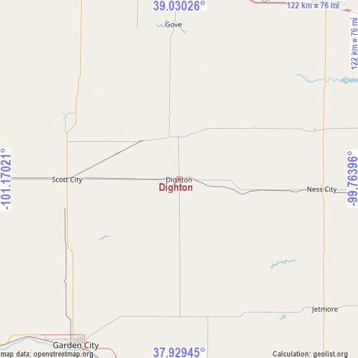
Dighton GPS coordinates[2]
38° 28' 55.056" North, 100° 28' 1.488" West
| Map corner | latitude | longitude |
|---|---|---|
| Upper-left | 39.03026°, | -101.17021° |
| Center: | 38.48196°, | -100.46708° |
| Lower-right: | 37.92945°, | -99.76396° |
| Map W x H: | 122.4×122.4 km | = 76.1×76.1mi |
| max Lat: | 71.29058° ⇑58.9% North |
| Dighton: | 38.48196° |
| min Lat: | ⇓41.1% South 19.06759° |
| min Long | Dighton | max Long |
| -171.73463° | -100.46708° | -66.98998° |
| W 19%⇐ | ⇒81% E |
Elevation
Elevation of Dighton is 850 m = 2789 ft, and this is 555.2 m = 1822 ft above average elevation for this country.
| Max E: |
3189 m = 10463 ft | 7.6% |
| Dighton | 850 m 2789 ft | |
| Avg. | 294.8 m = 967 ft | |
Min E: |
-60 m = -197 ft | 92.4% |
See also: United States elevation on elevation.city.
Geographical zone
Dighton is located in North temperate zone (between Tropic of Cancer and the Arctic Circle). Distance of this Northern Tropic circle is 1672.9 km =1039.5 mi to South.| Distance of | km | miles | from Dighton |
|---|---|---|---|
| North Pole | 5728.3 | 3559.4 | to North |
| Arctic Circle | 3122.4 | 1940.2 | to North |
| Tropic Cancer | 1672.9 | 1039.5 | to South |
| Equator | 4278.8 | 2658.7 | to South |


Nearby cities:
15 places around Dighton: (largest is in red/bold)
• Cimarron
75.8 km =47.1 mi,  172°
172°
• Deerfield
80.6 km =50.1 mi,  226°
226°
• Dodge City
90.1 km =56 mi,  154°
154°
• Ellis
93.6 km =58.2 mi,  57°
57°
• Garden City
66.9 km =41.6 mi,  211°
211°
• Gove
52.9 km =32.9 mi,  357°
357°
• Holcomb
71.6 km =44.5 mi,  219°
219°
• Jetmore
66.8 km =41.5 mi,  131°
131°
• Lakin
91.4 km =56.8 mi, 228°
• Leoti
77.6 km =48.2 mi,  269°
269°
• Ness City
48.9 km =30.4 mi,  93°
93°
• Oakley
80.2 km =49.8 mi,  334°
334°
• Quinter
68.4 km =42.5 mi,  17°
17°
• Scott City
38.3 km =23.8 mi, 270°
• WaKeeney
79 km =49.1 mi,  40°
40°
Sources, notices
• [Note1] Compared only with cities in United States existing in our database
• [Src1] Map data: © OpenStreetMap contributors (CC-BY-SA)
• [Src2] Other city data from geonames.org with taken over terms of usage.
• [Src3] Geographical zone / Annual Mean Temperature by Robert A. Rohde @ Wikipedia
