Falmouth geodata
Falmouth (Kentucky) is a seat of a second-order administrative division; located in United States in America/New_York (GMT-4) time zone. With population of 2,127 people, there are 11538 cities with bigger population in this country. Compared to other cities in United States, 57.6% of cities are located further ↑North; 58.2% of cities are located further ←West and 57.1% of cities have higher elevation than Falmouth. Note1


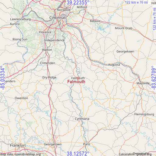
Falmouth GPS coordinates[2]
38° 40' 36.264" North, 84° 19' 48.756" West
| Map corner | latitude | longitude |
|---|---|---|
| Upper-left | 39.22355°, | -85.03334° |
| Center: | 38.67674°, | -84.33021° |
| Lower-right: | 38.12572°, | -83.62709° |
| Map W x H: | 122.1×122.1 km | = 75.9×75.9mi |
| max Lat: | 71.29058° ⇑57.6% North |
| Falmouth: | 38.67674° |
| min Lat: | ⇓42.4% South 19.06759° |
| min Long | Falmouth | max Long |
| -171.73463° | -84.33021° | -66.98998° |
| W 58.2%⇐ | ⇒41.8% E |
Elevation
Elevation of Falmouth is 170 m = 558 ft, and this is 124.8 m = 409 ft below average elevation for this country.
| Max E: |
3189 m = 10463 ft | 57.1% |
| Avg. | 294.8 m = 967 ft | |
| Falmouth | 170 m = 558 ft | |
Min E: |
-60 m = -197 ft | 42.9% |
See also: United States elevation on elevation.city.
Geographical zone
Falmouth is located in North temperate zone (between Tropic of Cancer and the Arctic Circle). Distance of this Northern Tropic circle is 1694.5 km =1052.9 mi to South.| Distance of | km | miles | from Falmouth |
|---|---|---|---|
| North Pole | 5706.6 | 3545.9 | to North |
| Arctic Circle | 3100.7 | 1926.7 | to North |
| Tropic Cancer | 1694.5 | 1052.9 | to South |
| Equator | 4300.5 | 2672.2 | to South |


Nearby cities:
15 places around Falmouth: (largest is in red/bold)
• Alexandria
31.8 km =19.8 mi,  350°
350°
• Augusta
30.1 km =18.7 mi,  69°
69°
• Brooksville
23 km =14.3 mi,  88°
88°
• Butler
12.7 km =7.9 mi,  344°
344°
• Claryville
27.5 km =17.1 mi, 348°
• Crittenden
26.6 km =16.5 mi,  296°
296°
• Cynthiana
32 km =19.9 mi,  174°
174°
• Dry Ridge
22.6 km =14 mi,  271°
271°
• Felicity
27.1 km =16.8 mi,  48°
48°
• Mount Olivet
30.2 km =18.8 mi,  122°
122°
• New Richmond
30.5 km =19 mi,  8°
8°
• Ryland Heights
33.3 km =20.7 mi, 339°
• Verona
32.7 km =20.3 mi, 298°
• Walton
32.8 km =20.4 mi,  312°
312°
• Williamstown
20.5 km =12.7 mi,  257°
257°
Sources, notices
• [Note1] Compared only with cities in United States existing in our database
• [Src1] Map data: © OpenStreetMap contributors (CC-BY-SA)
• [Src2] Other city data from geonames.org with taken over terms of usage.
• [Src3] Geographical zone / Annual Mean Temperature by Robert A. Rohde @ Wikipedia
