Brooksville geodata
Brooksville (Kentucky) is a seat of a second-order administrative division; located in United States in America/New_York (GMT-4) time zone. With population of 638 people, there are 19285 cities with bigger population in this country. Compared to other cities in United States, 57.6% of cities are located further ↑North; 59.1% of cities are located further ←West and 70.3% of cities have lower elevation than Brooksville. Note1


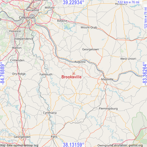
Brooksville GPS coordinates[2]
38° 40' 57.252" North, 84° 3' 56.736" West
| Map corner | latitude | longitude |
|---|---|---|
| Upper-left | 39.22934°, | -84.76889° |
| Center: | 38.68257°, | -84.06576° |
| Lower-right: | 38.13159°, | -83.36264° |
| Map W x H: | 122.1×122.1 km | = 75.9×75.9mi |
| max Lat: | 71.29058° ⇑57.6% North |
| Brooksville: | 38.68257° |
| min Lat: | ⇓42.4% South 19.06759° |
| min Long | Brooksville | max Long |
| -171.73463° | -84.06576° | -66.98998° |
| W 59.1%⇐ | ⇒40.9% E |
Elevation
Elevation of Brooksville is 287 m = 942 ft, and this is 7.8 m = 26 ft below average elevation for this country.
| Max E: |
3189 m = 10463 ft | 29.7% |
| Avg. | 294.8 m = 967 ft | |
| Brooksville | 287 m = 942 ft | |
Min E: |
-60 m = -197 ft | 70.3% |
See also: United States elevation on elevation.city.
Geographical zone
Brooksville is located in North temperate zone (between Tropic of Cancer and the Arctic Circle). Distance of this Northern Tropic circle is 1695.2 km =1053.3 mi to South.| Distance of | km | miles | from Brooksville |
|---|---|---|---|
| North Pole | 5706 | 3545.5 | to North |
| Arctic Circle | 3100.1 | 1926.3 | to North |
| Tropic Cancer | 1695.2 | 1053.3 | to South |
| Equator | 4301.1 | 2672.6 | to South |


Nearby cities:
15 places around Brooksville: (largest is in red/bold)
• Aberdeen
26.6 km =16.5 mi,  96°
96°
• Augusta
11.2 km =7 mi,  27°
27°
• Bethel
31.3 km =19.4 mi,  357°
357°
• Butler
28.8 km =17.9 mi,  293°
293°
• Cynthiana
38.1 km =23.7 mi,  211°
211°
• Falmouth
23 km =14.3 mi,  268°
268°
• Felicity
17.6 km =10.9 mi,  351°
351°
• Georgetown
24.6 km =15.3 mi, 34°
• Hamersville
27.1 km =16.8 mi,  15°
15°
• Maysville
28.3 km =17.6 mi, 99°
• Mount Olivet
17 km =10.6 mi,  171°
171°
• New Richmond
34.9 km =21.7 mi,  327°
327°
• Old Washington
23.5 km =14.6 mi,  108°
108°
• Ripley
20.4 km =12.7 mi,  69°
69°
• Russellville
31.7 km =19.7 mi,  49°
49°
Sources, notices
• [Note1] Compared only with cities in United States existing in our database
• [Src1] Map data: © OpenStreetMap contributors (CC-BY-SA)
• [Src2] Other city data from geonames.org with taken over terms of usage.
• [Src3] Geographical zone / Annual Mean Temperature by Robert A. Rohde @ Wikipedia
