Cynthiana geodata
Cynthiana (Kentucky) is a seat of a second-order administrative division; located in United States in America/New_York (GMT-4) time zone. With population of 6,423 people, there are 6162 cities with bigger population in this country. Compared to other cities in United States, 59.5% of cities are located further ↑North; 58.3% of cities are located further ←West and 55.8% of cities have lower elevation than Cynthiana. Note1


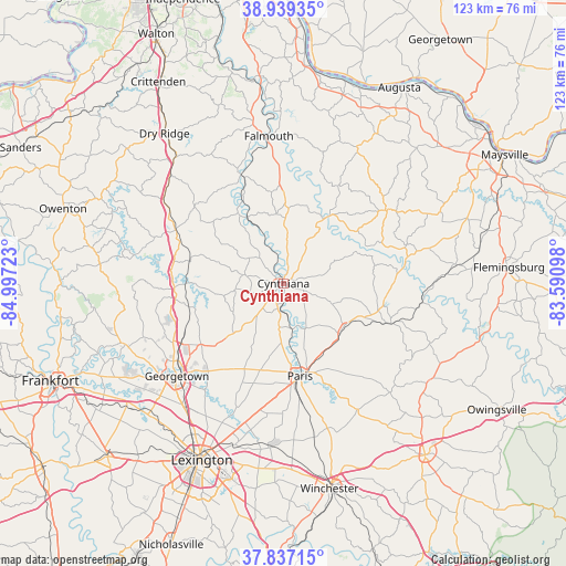
Cynthiana GPS coordinates[2]
38° 23' 25.26" North, 84° 17' 38.76" West
| Map corner | latitude | longitude |
|---|---|---|
| Upper-left | 38.93935°, | -84.99723° |
| Center: | 38.39035°, | -84.2941° |
| Lower-right: | 37.83715°, | -83.59098° |
| Map W x H: | 122.6×122.6 km | = 76.2×76.2mi |
| max Lat: | 71.29058° ⇑59.5% North |
| Cynthiana: | 38.39035° |
| min Lat: | ⇓40.5% South 19.06759° |
| min Long | Cynthiana | max Long |
| -171.73463° | -84.2941° | -66.98998° |
| W 58.3%⇐ | ⇒41.7% E |
Elevation
Elevation of Cynthiana is 222 m = 728 ft, and this is 72.8 m = 239 ft below average elevation for this country.
| Max E: |
3189 m = 10463 ft | 44.2% |
| Avg. | 294.8 m = 967 ft | |
| Cynthiana | 222 m = 728 ft | |
Min E: |
-60 m = -197 ft | 55.8% |
See also: United States elevation on elevation.city.
Geographical zone
Cynthiana is located in North temperate zone (between Tropic of Cancer and the Arctic Circle). Distance of this Northern Tropic circle is 1662.7 km =1033.2 mi to South.| Distance of | km | miles | from Cynthiana |
|---|---|---|---|
| North Pole | 5738.5 | 3565.7 | to North |
| Arctic Circle | 3132.6 | 1946.5 | to North |
| Tropic Cancer | 1662.7 | 1033.2 | to South |
| Equator | 4268.6 | 2652.4 | to South |


Nearby cities:
15 places around Cynthiana: (largest is in red/bold)
• Brooksville
38.1 km =23.7 mi,  31°
31°
• Butler
44.5 km =27.7 mi,  351°
351°
• Carlisle
24.8 km =15.4 mi,  110°
110°
• Dry Ridge
41.4 km =25.7 mi,  321°
321°
• Falmouth
32 km =19.9 mi, 354°
• Georgetown
30.6 km =19 mi,  229°
229°
• Lexington-Fayette
40.5 km =25.2 mi,  200°
200°
• Midway
43.2 km =26.8 mi, 231°
• Millersburg
16.1 km =10 mi,  127°
127°
• Mount Olivet
27.3 km =17 mi,  54°
54°
• Mount Vernon
44.2 km =27.5 mi, 203°
• North Middletown
31.6 km =19.6 mi,  149°
149°
• Paris
20.4 km =12.7 mi,  169°
169°
• Stamping Ground
36.7 km =22.8 mi,  248°
248°
• Williamstown
36 km =22.4 mi, 319°
Sources, notices
• [Note1] Compared only with cities in United States existing in our database
• [Src1] Map data: © OpenStreetMap contributors (CC-BY-SA)
• [Src2] Other city data from geonames.org with taken over terms of usage.
• [Src3] Geographical zone / Annual Mean Temperature by Robert A. Rohde @ Wikipedia
