Calhoun geodata
Calhoun (Kentucky) is a seat of a second-order administrative division; located in United States in America/Chicago (GMT-5) time zone. With population of 762 people, there are 18109 cities with bigger population in this country. Compared to other cities in United States, 63.9% of cities are located further ↑North; 50.2% of cities are located further →East and 66.4% of cities have higher elevation than Calhoun. Note1


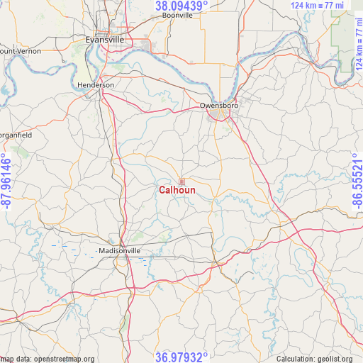
Calhoun GPS coordinates[2]
37° 32' 20.184" North, 87° 15' 29.988" West
| Map corner | latitude | longitude |
|---|---|---|
| Upper-left | 38.09439°, | -87.96146° |
| Center: | 37.53894°, | -87.25833° |
| Lower-right: | 36.97932°, | -86.55521° |
| Map W x H: | 124×124 km | = 77.1×77.1mi |
| max Lat: | 71.29058° ⇑63.9% North |
| Calhoun: | 37.53894° |
| min Lat: | ⇓36.1% South 19.06759° |
| min Long | Calhoun | max Long |
| -171.73463° | -87.25833° | -66.98998° |
| W 49.8%⇐ | ⇒50.2% E |
Elevation
Elevation of Calhoun is 121 m = 397 ft, and this is 173.8 m = 570 ft below average elevation for this country.
| Max E: |
3189 m = 10463 ft | 66.4% |
| Avg. | 294.8 m = 967 ft | |
| Calhoun | 121 m = 397 ft | |
Min E: |
-60 m = -197 ft | 33.6% |
See also: United States elevation on elevation.city.
Geographical zone
Calhoun is located in North temperate zone (between Tropic of Cancer and the Arctic Circle). Distance of this Northern Tropic circle is 1568 km =974.3 mi to South.| Distance of | km | miles | from Calhoun |
|---|---|---|---|
| North Pole | 5833.1 | 3624.5 | to North |
| Arctic Circle | 3227.2 | 2005.3 | to North |
| Tropic Cancer | 1568 | 974.3 | to South |
| Equator | 4173.9 | 2593.5 | to South |


Nearby cities:
15 places around Calhoun: (largest is in red/bold)
• Beaver Dam
37 km =23 mi,  114°
114°
• Central City
29.7 km =18.5 mi,  156°
156°
• Earlington
37 km =23 mi,  217°
217°
• Greenville
38.2 km =23.7 mi,  169°
169°
• Hanson
23.8 km =14.8 mi,  235°
235°
• Hartford
32.3 km =20.1 mi, 107°
• Livermore
12.3 km =7.6 mi, 114°
• Madisonville
31.6 km =19.6 mi, 222°
• Masonville
24.8 km =15.4 mi,  52°
52°
• Morehead
30.6 km =19 mi, 166°
• Owensboro
29.1 km =18.1 mi,  26°
26°
• Powderly
34.7 km =21.6 mi, 165°
• Robards
29.5 km =18.3 mi,  300°
300°
• Sebree
25 km =15.5 mi,  287°
287°
• Whitesville
37.7 km =23.4 mi,  64°
64°
Sources, notices
• [Note1] Compared only with cities in United States existing in our database
• [Src1] Map data: © OpenStreetMap contributors (CC-BY-SA)
• [Src2] Other city data from geonames.org with taken over terms of usage.
• [Src3] Geographical zone / Annual Mean Temperature by Robert A. Rohde @ Wikipedia
