Robards geodata
Robards (Kentucky) is a populated place; located in United States in America/Chicago (GMT-5) time zone. With population of 513 people, there are 20718 cities with bigger population in this country. Compared to other cities in United States, 63.4% of cities are located further ↑North; 50.9% of cities are located further →East and 64.2% of cities have higher elevation than Robards. Note1


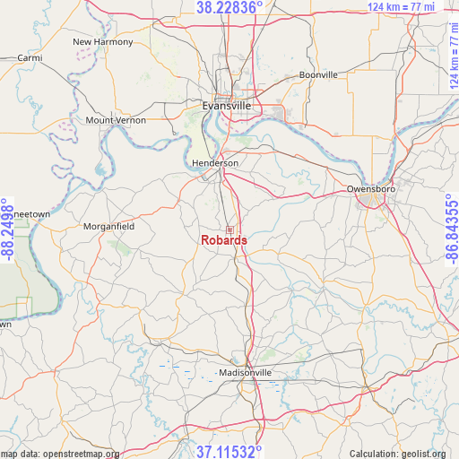
Robards GPS coordinates[2]
37° 40' 26.148" North, 87° 32' 48.012" West
| Map corner | latitude | longitude |
|---|---|---|
| Upper-left | 38.22836°, | -88.2498° |
| Center: | 37.67393°, | -87.54667° |
| Lower-right: | 37.11532°, | -86.84355° |
| Map W x H: | 123.8×123.8 km | = 76.9×76.9mi |
| max Lat: | 71.29058° ⇑63.4% North |
| Robards: | 37.67393° |
| min Lat: | ⇓36.6% South 19.06759° |
| min Long | Robards | max Long |
| -171.73463° | -87.54667° | -66.98998° |
| W 49.1%⇐ | ⇒50.9% E |
Elevation
Elevation of Robards is 132 m = 433 ft, and this is 162.8 m = 534 ft below average elevation for this country.
| Max E: |
3189 m = 10463 ft | 64.2% |
| Avg. | 294.8 m = 967 ft | |
| Robards | 132 m = 433 ft | |
Min E: |
-60 m = -197 ft | 35.8% |
See also: United States elevation on elevation.city.
Geographical zone
Robards is located in North temperate zone (between Tropic of Cancer and the Arctic Circle). Distance of this Northern Tropic circle is 1583 km =983.6 mi to South.| Distance of | km | miles | from Robards |
|---|---|---|---|
| North Pole | 5818.1 | 3615.2 | to North |
| Arctic Circle | 3212.2 | 1996 | to North |
| Tropic Cancer | 1583 | 983.6 | to South |
| Equator | 4188.9 | 2602.9 | to South |


Nearby cities:
15 places around Robards: (largest is in red/bold)
• Breckinridge Center
27.9 km =17.3 mi,  272°
272°
• Calhoun
29.5 km =18.3 mi,  120°
120°
• Clay
32.6 km =20.3 mi,  227°
227°
• Corydon
15.8 km =9.8 mi,  299°
299°
• Dixon
21.5 km =13.4 mi,  216°
216°
• Evansville
33.5 km =20.8 mi,  358°
358°
• Hanson
29.1 km =18.1 mi,  168°
168°
• Hatfield
38.1 km =23.7 mi,  48°
48°
• Henderson
18.4 km =11.4 mi,  348°
348°
• Madisonville
38.7 km =24 mi, 173°
• Morganfield
32.6 km =20.3 mi, 271°
• Newburgh
32.5 km =20.2 mi,  22°
22°
• Providence
36.2 km =22.5 mi,  211°
211°
• Sebree
7.6 km =4.7 mi, 167°
• Uniontown
35.6 km =22.1 mi,  288°
288°
Sources, notices
• [Note1] Compared only with cities in United States existing in our database
• [Src1] Map data: © OpenStreetMap contributors (CC-BY-SA)
• [Src2] Other city data from geonames.org with taken over terms of usage.
• [Src3] Geographical zone / Annual Mean Temperature by Robert A. Rohde @ Wikipedia
