Sebree geodata
Sebree (Kentucky) is a populated place; located in United States in America/Chicago (GMT-5) time zone. With population of 1,559 people, there are 13441 cities with bigger population in this country. Compared to other cities in United States, 63.6% of cities are located further ↑North; 50.8% of cities are located further →East and 66.7% of cities have higher elevation than Sebree. Note1


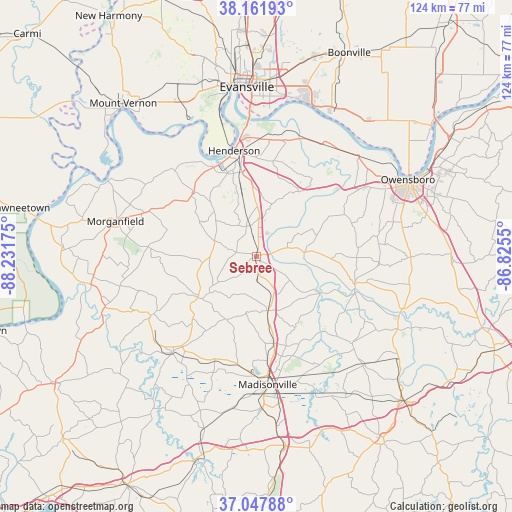
Sebree GPS coordinates[2]
37° 36' 25.164" North, 87° 31' 43.032" West
| Map corner | latitude | longitude |
|---|---|---|
| Upper-left | 38.16193°, | -88.23175° |
| Center: | 37.60699°, | -87.52862° |
| Lower-right: | 37.04788°, | -86.8255° |
| Map W x H: | 123.9×123.9 km | = 77×77mi |
| max Lat: | 71.29058° ⇑63.6% North |
| Sebree: | 37.60699° |
| min Lat: | ⇓36.4% South 19.06759° |
| min Long | Sebree | max Long |
| -171.73463° | -87.52862° | -66.98998° |
| W 49.2%⇐ | ⇒50.8% E |
Elevation
Elevation of Sebree is 119 m = 390 ft, and this is 175.8 m = 577 ft below average elevation for this country.
| Max E: |
3189 m = 10463 ft | 66.7% |
| Avg. | 294.8 m = 967 ft | |
| Sebree | 119 m = 390 ft | |
Min E: |
-60 m = -197 ft | 33.3% |
See also: United States elevation on elevation.city.
Geographical zone
Sebree is located in North temperate zone (between Tropic of Cancer and the Arctic Circle). Distance of this Northern Tropic circle is 1575.6 km =979 mi to South.| Distance of | km | miles | from Sebree |
|---|---|---|---|
| North Pole | 5825.6 | 3619.9 | to North |
| Arctic Circle | 3219.7 | 2000.6 | to North |
| Tropic Cancer | 1575.6 | 979 | to South |
| Equator | 4181.5 | 2598.3 | to South |


Nearby cities:
15 places around Sebree: (largest is in red/bold)
• Breckinridge Center
30.6 km =19 mi,  285°
285°
• Calhoun
25 km =15.5 mi,  107°
107°
• Clay
29.5 km =18.3 mi,  240°
240°
• Corydon
21.6 km =13.4 mi,  314°
314°
• Dixon
17.4 km =10.8 mi, 235°
• Earlington
37 km =23 mi,  177°
177°
• Hanson
21.5 km =13.4 mi,  168°
168°
• Henderson
26 km =16.2 mi,  348°
348°
• Livermore
37.2 km =23.1 mi, 109°
• Madisonville
31.1 km =19.3 mi, 175°
• Morganfield
35.2 km =21.9 mi,  283°
283°
• Newburgh
39.1 km =24.3 mi,  16°
16°
• Providence
31.1 km =19.3 mi,  221°
221°
• Robards
7.6 km =4.7 mi, 347°
• Uniontown
40 km =24.9 mi,  297°
297°
Sources, notices
• [Note1] Compared only with cities in United States existing in our database
• [Src1] Map data: © OpenStreetMap contributors (CC-BY-SA)
• [Src2] Other city data from geonames.org with taken over terms of usage.
• [Src3] Geographical zone / Annual Mean Temperature by Robert A. Rohde @ Wikipedia
