Grayson geodata
Grayson (Kentucky) is a seat of a second-order administrative division; located in United States in America/New_York (GMT-4) time zone. With population of 4,058 people, there are 8153 cities with bigger population in this country. Compared to other cities in United States, 59.8% of cities are located further ↑North; 62.1% of cities are located further ←West and 51.4% of cities have higher elevation than Grayson. Note1


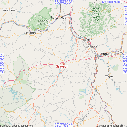
Grayson GPS coordinates[2]
38° 19' 57.288" North, 82° 56' 54.6" West
| Map corner | latitude | longitude |
|---|---|---|
| Upper-left | 38.88203°, | -83.65163° |
| Center: | 38.33258°, | -82.9485° |
| Lower-right: | 37.77894°, | -82.24538° |
| Map W x H: | 122.7×122.7 km | = 76.2×76.2mi |
| max Lat: | 71.29058° ⇑59.8% North |
| Grayson: | 38.33258° |
| min Lat: | ⇓40.2% South 19.06759° |
| min Long | Grayson | max Long |
| -171.73463° | -82.9485° | -66.98998° |
| W 62.1%⇐ | ⇒37.9% E |
Elevation
Elevation of Grayson is 193 m = 633 ft, and this is 101.8 m = 334 ft below average elevation for this country.
| Max E: |
3189 m = 10463 ft | 51.4% |
| Avg. | 294.8 m = 967 ft | |
| Grayson | 193 m = 633 ft | |
Min E: |
-60 m = -197 ft | 48.6% |
See also: United States elevation on elevation.city.
Geographical zone
Grayson is located in North temperate zone (between Tropic of Cancer and the Arctic Circle). Distance of this Northern Tropic circle is 1656.3 km =1029.2 mi to South.| Distance of | km | miles | from Grayson |
|---|---|---|---|
| North Pole | 5744.9 | 3569.7 | to North |
| Arctic Circle | 3139 | 1950.5 | to North |
| Tropic Cancer | 1656.3 | 1029.2 | to South |
| Equator | 4262.2 | 2648.4 | to South |


Nearby cities:
15 places around Grayson: (largest is in red/bold)
• Ashland
31.5 km =19.6 mi,  59°
59°
• Bellefonte
28.7 km =17.8 mi,  51°
51°
• Cannonsburg
22.3 km =13.9 mi,  73°
73°
• Catlettsburg
31.4 km =19.5 mi,  75°
75°
• Flatwoods
29.2 km =18.1 mi,  43°
43°
• Greenup
28.7 km =17.8 mi,  21°
21°
• Ironville
26.2 km =16.3 mi, 58°
• Meads
22.7 km =14.1 mi, 66°
• Olive Hill
20 km =12.4 mi,  259°
259°
• Raceland
30 km =18.6 mi, 39°
• Russell
30 km =18.6 mi, 46°
• Sandy Hook
31.5 km =19.6 mi,  209°
209°
• Westwood
29.5 km =18.3 mi, 55°
• Worthington
30.9 km =19.2 mi, 39°
• Wurtland
28.4 km =17.6 mi,  31°
31°
Sources, notices
• [Note1] Compared only with cities in United States existing in our database
• [Src1] Map data: © OpenStreetMap contributors (CC-BY-SA)
• [Src2] Other city data from geonames.org with taken over terms of usage.
• [Src3] Geographical zone / Annual Mean Temperature by Robert A. Rohde @ Wikipedia
