Sandy Hook geodata
Sandy Hook (Kentucky) is a seat of a second-order administrative division; located in United States in America/New_York (GMT-4) time zone. With population of 630 people, there are 19355 cities with bigger population in this country. Compared to other cities in United States, 61.2% of cities are located further ↑North; 61.7% of cities are located further ←West and 58.4% of cities have lower elevation than Sandy Hook. Note1


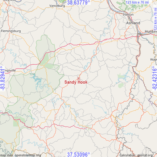
Sandy Hook GPS coordinates[2]
38° 5' 11.292" North, 83° 7' 34.608" West
| Map corner | latitude | longitude |
|---|---|---|
| Upper-left | 38.63779°, | -83.82941° |
| Center: | 38.08647°, | -83.12628° |
| Lower-right: | 37.53096°, | -82.42316° |
| Map W x H: | 123.1×123.1 km | = 76.5×76.5mi |
| max Lat: | 71.29058° ⇑61.2% North |
| Sandy Hook: | 38.08647° |
| min Lat: | ⇓38.8% South 19.06759° |
| min Long | Sandy Hook | max Long |
| -171.73463° | -83.12628° | -66.98998° |
| W 61.7%⇐ | ⇒38.3% E |
Elevation
Elevation of Sandy Hook is 232 m = 761 ft, and this is 62.8 m = 206 ft below average elevation for this country.
| Max E: |
3189 m = 10463 ft | 41.6% |
| Avg. | 294.8 m = 967 ft | |
| Sandy Hook | 232 m = 761 ft | |
Min E: |
-60 m = -197 ft | 58.4% |
See also: United States elevation on elevation.city.
Geographical zone
Sandy Hook is located in North temperate zone (between Tropic of Cancer and the Arctic Circle). Distance of this Northern Tropic circle is 1628.9 km =1012.2 mi to South.| Distance of | km | miles | from Sandy Hook |
|---|---|---|---|
| North Pole | 5772.2 | 3586.7 | to North |
| Arctic Circle | 3166.4 | 1967.5 | to North |
| Tropic Cancer | 1628.9 | 1012.2 | to South |
| Equator | 4234.8 | 2631.4 | to South |


Nearby cities:
15 places around Sandy Hook: (largest is in red/bold)
• Auxier
50.5 km =31.4 mi,  140°
140°
• Cannonsburg
50 km =31.1 mi,  47°
47°
• Elkfork
13.5 km =8.4 mi,  182°
182°
• Fort Gay
46.5 km =28.9 mi,  85°
85°
• Frenchburg
46.3 km =28.8 mi,  250°
250°
• Grayson
31.5 km =19.6 mi,  29°
29°
• Louisa
45.9 km =28.5 mi, 86°
• Meads
51.4 km =31.9 mi, 45°
• Morehead
28.9 km =18 mi,  292°
292°
• Olive Hill
24.1 km =15 mi,  350°
350°
• Paintsville
41.2 km =25.6 mi, 137°
• Prichard
49.2 km =30.6 mi,  69°
69°
• Salyersville
37.5 km =23.3 mi,  172°
172°
• Van Lear
47.7 km =29.6 mi, 137°
• West Liberty
21.7 km =13.5 mi,  212°
212°
Sources, notices
• [Note1] Compared only with cities in United States existing in our database
• [Src1] Map data: © OpenStreetMap contributors (CC-BY-SA)
• [Src2] Other city data from geonames.org with taken over terms of usage.
• [Src3] Geographical zone / Annual Mean Temperature by Robert A. Rohde @ Wikipedia
