Olive Hill geodata
Olive Hill (Kentucky) is a populated place; located in United States in America/New_York (GMT-4) time zone. With population of 1,599 people, there are 13302 cities with bigger population in this country. Compared to other cities in United States, 59.9% of cities are located further ↑North; 61.5% of cities are located further ←West and 58.2% of cities have lower elevation than Olive Hill. Note1


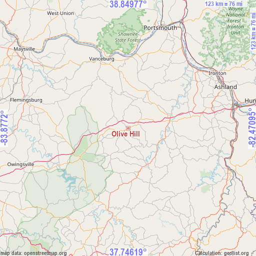
Olive Hill GPS coordinates[2]
38° 18' 0.288" North, 83° 10' 26.652" West
| Map corner | latitude | longitude |
|---|---|---|
| Upper-left | 38.84977°, | -83.8772° |
| Center: | 38.30008°, | -83.17407° |
| Lower-right: | 37.74619°, | -82.47095° |
| Map W x H: | 122.7×122.7 km | = 76.2×76.2mi |
| max Lat: | 71.29058° ⇑59.9% North |
| Olive Hill: | 38.30008° |
| min Lat: | ⇓40.1% South 19.06759° |
| min Long | Olive Hill | max Long |
| -171.73463° | -83.17407° | -66.98998° |
| W 61.5%⇐ | ⇒38.5% E |
Elevation
Elevation of Olive Hill is 231 m = 758 ft, and this is 63.8 m = 209 ft below average elevation for this country.
| Max E: |
3189 m = 10463 ft | 41.8% |
| Avg. | 294.8 m = 967 ft | |
| Olive Hill | 231 m = 758 ft | |
Min E: |
-60 m = -197 ft | 58.2% |
See also: United States elevation on elevation.city.
Geographical zone
Olive Hill is located in North temperate zone (between Tropic of Cancer and the Arctic Circle). Distance of this Northern Tropic circle is 1652.7 km =1026.9 mi to South.| Distance of | km | miles | from Olive Hill |
|---|---|---|---|
| North Pole | 5748.5 | 3572 | to North |
| Arctic Circle | 3142.6 | 1952.7 | to North |
| Tropic Cancer | 1652.7 | 1026.9 | to South |
| Equator | 4258.6 | 2646.2 | to South |


Nearby cities:
15 places around Olive Hill: (largest is in red/bold)
• Bellefonte
47.3 km =29.4 mi,  63°
63°
• Cannonsburg
42.3 km =26.3 mi,  76°
76°
• Elkfork
37.5 km =23.3 mi,  174°
174°
• Flatwoods
46.9 km =29.1 mi, 58°
• Garrison
34 km =21.1 mi,  0°
0°
• Grayson
20 km =12.4 mi, 79°
• Greenup
42.6 km =26.5 mi,  44°
44°
• Ironville
45.4 km =28.2 mi,  67°
67°
• Meads
42.4 km =26.3 mi, 72°
• Morehead
26 km =16.2 mi,  240°
240°
• Raceland
47.1 km =29.3 mi, 55°
• Sandy Hook
24.1 km =15 mi, 170°
• Vanceburg
35.6 km =22.1 mi,  339°
339°
• West Liberty
42.8 km =26.6 mi,  190°
190°
• Wurtland
44.3 km =27.5 mi,  51°
51°
Sources, notices
• [Note1] Compared only with cities in United States existing in our database
• [Src1] Map data: © OpenStreetMap contributors (CC-BY-SA)
• [Src2] Other city data from geonames.org with taken over terms of usage.
• [Src3] Geographical zone / Annual Mean Temperature by Robert A. Rohde @ Wikipedia
