Irvington geodata
Irvington (Kentucky) is a populated place; located in United States in America/Chicago (GMT-5) time zone. With population of 1,184 people, there are 15208 cities with bigger population in this country. Compared to other cities in United States, 62.3% of cities are located further ↑North; 52.1% of cities are located further ←West and 51.6% of cities have higher elevation than Irvington. Note1


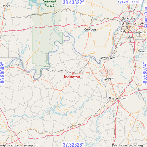
Irvington GPS coordinates[2]
37° 52' 49.224" North, 86° 17' 1.896" West
| Map corner | latitude | longitude |
|---|---|---|
| Upper-left | 38.43322°, | -86.98699° |
| Center: | 37.88034°, | -86.28386° |
| Lower-right: | 37.32328°, | -85.58074° |
| Map W x H: | 123.4×123.4 km | = 76.7×76.7mi |
| max Lat: | 71.29058° ⇑62.3% North |
| Irvington: | 37.88034° |
| min Lat: | ⇓37.7% South 19.06759° |
| min Long | Irvington | max Long |
| -171.73463° | -86.28386° | -66.98998° |
| W 52.1%⇐ | ⇒47.9% E |
Elevation
Elevation of Irvington is 192 m = 630 ft, and this is 102.8 m = 337 ft below average elevation for this country.
| Max E: |
3189 m = 10463 ft | 51.6% |
| Avg. | 294.8 m = 967 ft | |
| Irvington | 192 m = 630 ft | |
Min E: |
-60 m = -197 ft | 48.4% |
See also: United States elevation on elevation.city.
Geographical zone
Irvington is located in North temperate zone (between Tropic of Cancer and the Arctic Circle). Distance of this Northern Tropic circle is 1606 km =997.9 mi to South.| Distance of | km | miles | from Irvington |
|---|---|---|---|
| North Pole | 5795.2 | 3601 | to North |
| Arctic Circle | 3189.3 | 1981.7 | to North |
| Tropic Cancer | 1606 | 997.9 | to South |
| Equator | 4211.9 | 2617.2 | to South |


Nearby cities:
15 places around Irvington: (largest is in red/bold)
• Brandenburg
16.6 km =10.3 mi,  37°
37°
• Cannelton
40.6 km =25.2 mi,  274°
274°
• Cecilia
37.4 km =23.2 mi,  129°
129°
• Clarkson
43.2 km =26.8 mi,  172°
172°
• Cloverport
31.1 km =19.3 mi,  260°
260°
• Corydon
39.5 km =24.5 mi,  21°
21°
• Doe Valley
17 km =10.6 mi,  59°
59°
• Elizabethtown
42.7 km =26.5 mi,  119°
119°
• Fort Knox
28.1 km =17.5 mi,  87°
87°
• Hardinsburg
19.1 km =11.9 mi,  234°
234°
• Hawesville
41.4 km =25.7 mi, 273°
• Muldraugh
26.4 km =16.4 mi,  76°
76°
• Radcliff
29.7 km =18.5 mi,  98°
98°
• Vine Grove
27.7 km =17.2 mi,  106°
106°
• West Point
32.7 km =20.3 mi,  66°
66°
Sources, notices
• [Note1] Compared only with cities in United States existing in our database
• [Src1] Map data: © OpenStreetMap contributors (CC-BY-SA)
• [Src2] Other city data from geonames.org with taken over terms of usage.
• [Src3] Geographical zone / Annual Mean Temperature by Robert A. Rohde @ Wikipedia
