Lawrenceburg geodata
Lawrenceburg (Kentucky) is a seat of a second-order administrative division; located in United States in America/New_York (GMT-4) time zone. With population of 11,103 people, there are 4155 cities with bigger population in this country. Compared to other cities in United States, 61.4% of cities are located further ↑North; 56.1% of cities are located further ←West and 60.1% of cities have lower elevation than Lawrenceburg. Note1


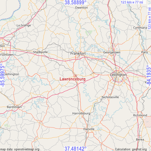
Lawrenceburg GPS coordinates[2]
38° 2' 14.28" North, 84° 53' 47.832" West
| Map corner | latitude | longitude |
|---|---|---|
| Upper-left | 38.58899°, | -85.59975° |
| Center: | 38.0373°, | -84.89662° |
| Lower-right: | 37.48142°, | -84.1935° |
| Map W x H: | 123.2×123.1 km | = 76.6×76.5mi |
| max Lat: | 71.29058° ⇑61.4% North |
| Lawrenceburg: | 38.0373° |
| min Lat: | ⇓38.6% South 19.06759° |
| min Long | Lawrenceburg | max Long |
| -171.73463° | -84.89662° | -66.98998° |
| W 56.1%⇐ | ⇒43.9% E |
Elevation
Elevation of Lawrenceburg is 240 m = 787 ft, and this is 54.8 m = 180 ft below average elevation for this country.
| Max E: |
3189 m = 10463 ft | 39.9% |
| Avg. | 294.8 m = 967 ft | |
| Lawrenceburg | 240 m = 787 ft | |
Min E: |
-60 m = -197 ft | 60.1% |
See also: United States elevation on elevation.city.
Geographical zone
Lawrenceburg is located in North temperate zone (between Tropic of Cancer and the Arctic Circle). Distance of this Northern Tropic circle is 1623.4 km =1008.7 mi to South.| Distance of | km | miles | from Lawrenceburg |
|---|---|---|---|
| North Pole | 5777.7 | 3590.1 | to North |
| Arctic Circle | 3171.8 | 1970.9 | to North |
| Tropic Cancer | 1623.4 | 1008.7 | to South |
| Equator | 4229.4 | 2628 | to South |


Nearby cities:
15 places around Lawrenceburg: (largest is in red/bold)
• Burgin
33.6 km =20.9 mi,  160°
160°
• Frankfort
18.3 km =11.4 mi,  6°
6°
• Georgetown
35.2 km =21.9 mi,  57°
57°
• Harrodsburg
30.9 km =19.2 mi,  171°
171°
• Jackson
23.7 km =14.7 mi, 174°
• Lexington
37.1 km =23.1 mi,  98°
98°
• Lexington-Fayette
38.4 km =23.9 mi,  87°
87°
• Midway
22.5 km =14 mi, 55°
• Monticello
30.8 km =19.1 mi, 99°
• Mount Vernon
35.2 km =21.9 mi, 92°
• Nicholasville
33.3 km =20.7 mi,  121°
121°
• Shelbyville
34.6 km =21.5 mi,  304°
304°
• Stamping Ground
31.9 km =19.8 mi,  35°
35°
• Versailles
14.7 km =9.1 mi,  83°
83°
• Wilmore
28.4 km =17.6 mi,  133°
133°
Sources, notices
• [Note1] Compared only with cities in United States existing in our database
• [Src1] Map data: © OpenStreetMap contributors (CC-BY-SA)
• [Src2] Other city data from geonames.org with taken over terms of usage.
• [Src3] Geographical zone / Annual Mean Temperature by Robert A. Rohde @ Wikipedia
