Lexington geodata
Lexington (Kentucky) is a seat of a second-order administrative division; located in United States in America/New_York (GMT-4) time zone. With population of 225,366 people, there are 107 cities with bigger population in this country. Compared to other cities in United States, 61.7% of cities are located further ↑North; 57.5% of cities are located further ←West and 72.4% of cities have lower elevation than Lexington. Note1


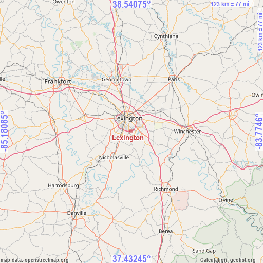
Lexington GPS coordinates[2]
37° 59' 19.284" North, 84° 28' 39.792" West
| Map corner | latitude | longitude |
|---|---|---|
| Upper-left | 38.54075°, | -85.18085° |
| Center: | 37.98869°, | -84.47772° |
| Lower-right: | 37.43245°, | -83.7746° |
| Map W x H: | 123.2×123.2 km | = 76.6×76.6mi |
| max Lat: | 71.29058° ⇑61.7% North |
| Lexington: | 37.98869° |
| min Lat: | ⇓38.3% South 19.06759° |
| min Long | Lexington | max Long |
| -171.73463° | -84.47772° | -66.98998° |
| W 57.5%⇐ | ⇒42.5% E |
Elevation
Elevation of Lexington is 298 m = 978 ft, and this is 3.2 m = 10 ft above average elevation for this country.
| Max E: |
3189 m = 10463 ft | 27.6% |
| Lexington | 298 m 978 ft | |
| Avg. | 294.8 m = 967 ft | |
Min E: |
-60 m = -197 ft | 72.4% |
See also: Lexington elevation on elevation.city.
Geographical zone
Lexington is located in North temperate zone (between Tropic of Cancer and the Arctic Circle). Distance of this Northern Tropic circle is 1618 km =1005.4 mi to South.| Distance of | km | miles | from Lexington |
|---|---|---|---|
| North Pole | 5783.1 | 3593.5 | to North |
| Arctic Circle | 3177.2 | 1974.2 | to North |
| Tropic Cancer | 1618 | 1005.4 | to South |
| Equator | 4223.9 | 2624.6 | to South |


Nearby cities:
15 places around Lexington: (largest is in red/bold)
• Burgin
36.4 km =22.6 mi,  224°
224°
• Georgetown
25.6 km =15.9 mi,  343°
343°
• Lawrenceburg
37.1 km =23.1 mi,  278°
278°
• Lexington-Fayette
7 km =4.3 mi,  13°
13°
• Midway
25.5 km =15.8 mi,  314°
314°
• Monticello
6.4 km =4 mi,  273°
273°
• Mount Vernon
4.4 km =2.7 mi, 339°
• Nicholasville
14.6 km =9.1 mi,  214°
214°
• North Middletown
36.5 km =22.7 mi,  61°
61°
• Paris
31.5 km =19.6 mi,  38°
38°
• Richmond
31.2 km =19.4 mi,  149°
149°
• Stamping Ground
36.4 km =22.6 mi,  329°
329°
• Versailles
23.2 km =14.4 mi,  287°
287°
• Wilmore
21.4 km =13.3 mi,  228°
228°
• Winchester
26.1 km =16.2 mi,  89°
89°
Sources, notices
• [Note1] Compared only with cities in United States existing in our database
• [Src1] Map data: © OpenStreetMap contributors (CC-BY-SA)
• [Src2] Other city data from geonames.org with taken over terms of usage.
• [Src3] Geographical zone / Annual Mean Temperature by Robert A. Rohde @ Wikipedia
