Springfield geodata
Springfield (Kentucky) is a seat of a second-order administrative division; located in United States in America/New_York (GMT-4) time zone. With population of 3,055 people, there are 9544 cities with bigger population in this country. Compared to other cities in United States, 63.3% of cities are located further ↑North; 55.3% of cities are located further ←West and 58.6% of cities have lower elevation than Springfield. Note1


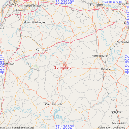
Springfield GPS coordinates[2]
37° 41' 7.224" North, 85° 13' 19.848" West
| Map corner | latitude | longitude |
|---|---|---|
| Upper-left | 38.23969°, | -85.92531° |
| Center: | 37.68534°, | -85.22218° |
| Lower-right: | 37.12682°, | -84.51906° |
| Map W x H: | 123.7×123.7 km | = 76.9×76.9mi |
| max Lat: | 71.29058° ⇑63.3% North |
| Springfield: | 37.68534° |
| min Lat: | ⇓36.7% South 19.06759° |
| min Long | Springfield | max Long |
| -171.73463° | -85.22218° | -66.98998° |
| W 55.3%⇐ | ⇒44.7% E |
Elevation
Elevation of Springfield is 233 m = 764 ft, and this is 61.8 m = 203 ft below average elevation for this country.
| Max E: |
3189 m = 10463 ft | 41.4% |
| Avg. | 294.8 m = 967 ft | |
| Springfield | 233 m = 764 ft | |
Min E: |
-60 m = -197 ft | 58.6% |
See also: United States elevation on elevation.city.
Geographical zone
Springfield is located in North temperate zone (between Tropic of Cancer and the Arctic Circle). Distance of this Northern Tropic circle is 1584.3 km =984.4 mi to South.| Distance of | km | miles | from Springfield |
|---|---|---|---|
| North Pole | 5816.8 | 3614.4 | to North |
| Arctic Circle | 3211 | 1995.2 | to North |
| Tropic Cancer | 1584.3 | 984.4 | to South |
| Equator | 4190.2 | 2603.7 | to South |


Nearby cities:
15 places around Springfield: (largest is in red/bold)
• Bardstown
25.5 km =15.8 mi,  302°
302°
• Bloomfield
26.4 km =16.4 mi,  341°
341°
• Burgin
40.8 km =25.4 mi,  79°
79°
• Campbellsville
39.5 km =24.5 mi,  195°
195°
• Danville
39.9 km =24.8 mi,  96°
96°
• Harrodsburg
34.4 km =21.4 mi, 75°
• Hodgenville
47.2 km =29.3 mi,  254°
254°
• Jackson
34.6 km =21.5 mi,  63°
63°
• Junction City
39.3 km =24.4 mi,  106°
106°
• Lebanon
13.1 km =8.1 mi,  191°
191°
• Liberty
47.8 km =29.7 mi,  148°
148°
• Loretto
16.7 km =10.4 mi, 250°
• New Haven
32.6 km =20.3 mi,  264°
264°
• Perryville
24.1 km =15 mi, 99°
• Taylorsville
39.9 km =24.8 mi, 344°
Sources, notices
• [Note1] Compared only with cities in United States existing in our database
• [Src1] Map data: © OpenStreetMap contributors (CC-BY-SA)
• [Src2] Other city data from geonames.org with taken over terms of usage.
• [Src3] Geographical zone / Annual Mean Temperature by Robert A. Rohde @ Wikipedia
