Lebanon Junction geodata
Lebanon Junction (Kentucky) is a populated place; located in United States in America/New_York (GMT-4) time zone. With population of 1,917 people, there are 12183 cities with bigger population in this country. Compared to other cities in United States, 62.5% of cities are located further ↑North; 53.7% of cities are located further ←West and 62.6% of cities have higher elevation than Lebanon Junction. Note1


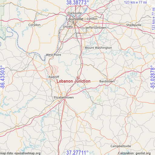
Lebanon Junction GPS coordinates[2]
37° 50' 4.236" North, 85° 43' 54.84" West
| Map corner | latitude | longitude |
|---|---|---|
| Upper-left | 38.38773°, | -86.43503° |
| Center: | 37.83451°, | -85.7319° |
| Lower-right: | 37.27711°, | -85.02878° |
| Map W x H: | 123.5×123.5 km | = 76.7×76.7mi |
| max Lat: | 71.29058° ⇑62.5% North |
| Lebanon Junction: | 37.83451° |
| min Lat: | ⇓37.5% South 19.06759° |
| min Long | Lebanon Junctio | max Long |
| -171.73463° | -85.7319° | -66.98998° |
| W 53.7%⇐ | ⇒46.3% E |
Elevation
Elevation of Lebanon Junction is 141 m = 463 ft, and this is 153.8 m = 505 ft below average elevation for this country.
| Max E: |
3189 m = 10463 ft | 62.6% |
| Avg. | 294.8 m = 967 ft | |
| Lebanon Junction | 141 m = 463 ft | |
Min E: |
-60 m = -197 ft | 37.4% |
See also: United States elevation on elevation.city.
Geographical zone
Lebanon Junction is located in North temperate zone (between Tropic of Cancer and the Arctic Circle). Distance of this Northern Tropic circle is 1600.9 km =994.8 mi to South.| Distance of | km | miles | from Lebanon Junction |
|---|---|---|---|
| North Pole | 5800.3 | 3604.1 | to North |
| Arctic Circle | 3194.4 | 1984.9 | to North |
| Tropic Cancer | 1600.9 | 994.8 | to South |
| Equator | 4206.8 | 2614 | to South |


Nearby cities:
15 places around Lebanon Junction: (largest is in red/bold)
• Bardstown
23.4 km =14.5 mi,  96°
96°
• Brooks
25.3 km =15.7 mi,  4°
4°
• Cecilia
27.2 km =16.9 mi,  226°
226°
• Elizabethtown
19.2 km =11.9 mi,  215°
215°
• Fort Knox
21.3 km =13.2 mi,  287°
287°
• Hebron Estates
24.6 km =15.3 mi,  13°
13°
• Hillview
26.5 km =16.5 mi, 8°
• Hollyvilla
28.8 km =17.9 mi,  357°
357°
• Muldraugh
25.5 km =15.8 mi,  296°
296°
• New Haven
23.2 km =14.4 mi,  147°
147°
• Pioneer Village
25.6 km =15.9 mi, 10°
• Radcliff
19.1 km =11.9 mi,  271°
271°
• Shepherdsville
17.2 km =10.7 mi, 4°
• Vine Grove
22.1 km =13.7 mi,  262°
262°
• West Point
26.1 km =16.2 mi,  314°
314°
Sources, notices
• [Note1] Compared only with cities in United States existing in our database
• [Src1] Map data: © OpenStreetMap contributors (CC-BY-SA)
• [Src2] Other city data from geonames.org with taken over terms of usage.
• [Src3] Geographical zone / Annual Mean Temperature by Robert A. Rohde @ Wikipedia
