New Haven geodata
New Haven (Kentucky) is a populated place; located in United States in America/New_York (GMT-4) time zone. With population of 887 people, there are 17063 cities with bigger population in this country. Compared to other cities in United States, 63.4% of cities are located further ↑North; 54.3% of cities are located further ←West and 61.9% of cities have higher elevation than New Haven. Note1


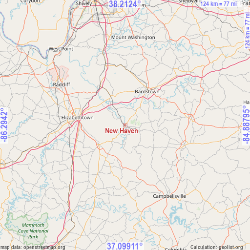
New Haven GPS coordinates[2]
37° 39' 28.224" North, 85° 35' 27.852" West
| Map corner | latitude | longitude |
|---|---|---|
| Upper-left | 38.2124°, | -86.2942° |
| Center: | 37.65784°, | -85.59107° |
| Lower-right: | 37.09911°, | -84.88795° |
| Map W x H: | 123.8×123.8 km | = 76.9×76.9mi |
| max Lat: | 71.29058° ⇑63.4% North |
| New Haven: | 37.65784° |
| min Lat: | ⇓36.6% South 19.06759° |
| min Long | New Haven | max Long |
| -171.73463° | -85.59107° | -66.98998° |
| W 54.3%⇐ | ⇒45.7% E |
Elevation
Elevation of New Haven is 145 m = 476 ft, and this is 149.8 m = 491 ft below average elevation for this country.
| Max E: |
3189 m = 10463 ft | 61.9% |
| Avg. | 294.8 m = 967 ft | |
| New Haven | 145 m = 476 ft | |
Min E: |
-60 m = -197 ft | 38.1% |
See also: United States elevation on elevation.city.
Geographical zone
New Haven is located in North temperate zone (between Tropic of Cancer and the Arctic Circle). Distance of this Northern Tropic circle is 1581.2 km =982.5 mi to South.| Distance of | km | miles | from New Haven |
|---|---|---|---|
| North Pole | 5819.9 | 3616.3 | to North |
| Arctic Circle | 3214 | 1997.1 | to North |
| Tropic Cancer | 1581.2 | 982.5 | to South |
| Equator | 4187.2 | 2601.8 | to South |


Nearby cities:
15 places around New Haven: (largest is in red/bold)
• Bardstown
20.1 km =12.5 mi,  32°
32°
• Bloomfield
37 km =23 mi,  40°
40°
• Cecilia
32.2 km =20 mi,  271°
271°
• Elizabethtown
23.9 km =14.9 mi,  279°
279°
• Hodgenville
16.1 km =10 mi,  234°
234°
• Lebanon
31.4 km =19.5 mi,  108°
108°
• Lebanon Junction
23.2 km =14.4 mi,  327°
327°
• Loretto
16.9 km =10.5 mi,  98°
98°
• Magnolia
27.3 km =17 mi,  209°
209°
• Radcliff
37.5 km =23.3 mi,  302°
302°
• Shepherdsville
38.4 km =23.9 mi,  343°
343°
• Springfield
32.6 km =20.3 mi,  84°
84°
• Summersville
37.1 km =23.1 mi,  173°
173°
• Upton
34.2 km =21.3 mi, 231°
• Vine Grove
38.3 km =23.8 mi, 296°
Sources, notices
• [Note1] Compared only with cities in United States existing in our database
• [Src1] Map data: © OpenStreetMap contributors (CC-BY-SA)
• [Src2] Other city data from geonames.org with taken over terms of usage.
• [Src3] Geographical zone / Annual Mean Temperature by Robert A. Rohde @ Wikipedia
