Morgantown geodata
Morgantown (Kentucky) is a seat of a second-order administrative division; located in United States in America/Chicago (GMT-5) time zone. With population of 2,475 people, there are 10686 cities with bigger population in this country. Compared to other cities in United States, 65.2% of cities are located further ↑North; 51.1% of cities are located further ←West and 56.6% of cities have higher elevation than Morgantown. Note1


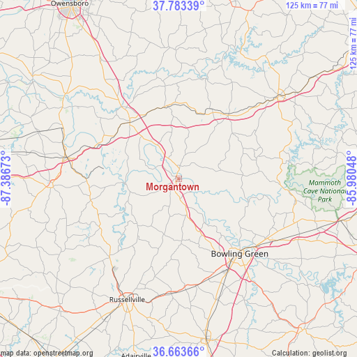
Morgantown GPS coordinates[2]
37° 13' 32.16" North, 86° 41' 0.96" West
| Map corner | latitude | longitude |
|---|---|---|
| Upper-left | 37.78339°, | -87.38673° |
| Center: | 37.2256°, | -86.6836° |
| Lower-right: | 36.66366°, | -85.98048° |
| Map W x H: | 124.5×124.5 km | = 77.4×77.4mi |
| max Lat: | 71.29058° ⇑65.2% North |
| Morgantown: | 37.2256° |
| min Lat: | ⇓34.8% South 19.06759° |
| min Long | Morgantown | max Long |
| -171.73463° | -86.6836° | -66.98998° |
| W 51.1%⇐ | ⇒48.9% E |
Elevation
Elevation of Morgantown is 173 m = 568 ft, and this is 121.8 m = 400 ft below average elevation for this country.
| Max E: |
3189 m = 10463 ft | 56.6% |
| Avg. | 294.8 m = 967 ft | |
| Morgantown | 173 m = 568 ft | |
Min E: |
-60 m = -197 ft | 43.4% |
See also: United States elevation on elevation.city.
Geographical zone
Morgantown is located in North temperate zone (between Tropic of Cancer and the Arctic Circle). Distance of this Northern Tropic circle is 1533.2 km =952.7 mi to South.| Distance of | km | miles | from Morgantown |
|---|---|---|---|
| North Pole | 5868 | 3646.2 | to North |
| Arctic Circle | 3262.1 | 2027 | to North |
| Tropic Cancer | 1533.2 | 952.7 | to South |
| Equator | 4139.1 | 2571.9 | to South |


Nearby cities:
15 places around Morgantown: (largest is in red/bold)
• Auburn
40.3 km =25 mi,  183°
183°
• Beaver Dam
26 km =16.2 mi,  319°
319°
• Beechmont
31.4 km =19.5 mi,  259°
259°
• Bowling Green
33.7 km =20.9 mi,  140°
140°
• Brownsville
37 km =23 mi,  95°
95°
• Caneyville
28 km =17.4 mi,  38°
38°
• Central City
39.6 km =24.6 mi,  281°
281°
• Drakesboro
32.4 km =20.1 mi,  268°
268°
• Greenville
43.9 km =27.3 mi, 266°
• Hartford
32 km =19.9 mi, 321°
• Leitchfield
44.6 km =27.7 mi,  50°
50°
• Lewisburg
35.4 km =22 mi,  221°
221°
• Morehead
43.9 km =27.3 mi, 276°
• Oak Grove
14.6 km =9.1 mi,  334°
334°
• Powderly
42.1 km =26.2 mi, 271°
Sources, notices
• [Note1] Compared only with cities in United States existing in our database
• [Src1] Map data: © OpenStreetMap contributors (CC-BY-SA)
• [Src2] Other city data from geonames.org with taken over terms of usage.
• [Src3] Geographical zone / Annual Mean Temperature by Robert A. Rohde @ Wikipedia
