Leitchfield geodata
Leitchfield (Kentucky) is a seat of a second-order administrative division; located in United States in America/Chicago (GMT-5) time zone. With population of 6,873 people, there are 5883 cities with bigger population in this country. Compared to other cities in United States, 64.1% of cities are located further ↑North; 52.1% of cities are located further ←West and 57.7% of cities have lower elevation than Leitchfield. Note1


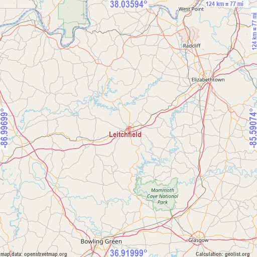
Leitchfield GPS coordinates[2]
37° 28' 48.18" North, 86° 17' 37.896" West
| Map corner | latitude | longitude |
|---|---|---|
| Upper-left | 38.03594°, | -86.99699° |
| Center: | 37.48005°, | -86.29386° |
| Lower-right: | 36.91999°, | -85.59074° |
| Map W x H: | 124.1×124.1 km | = 77.1×77.1mi |
| max Lat: | 71.29058° ⇑64.1% North |
| Leitchfield: | 37.48005° |
| min Lat: | ⇓35.9% South 19.06759° |
| min Long | Leitchfield | max Long |
| -171.73463° | -86.29386° | -66.98998° |
| W 52.1%⇐ | ⇒47.9% E |
Elevation
Elevation of Leitchfield is 229 m = 751 ft, and this is 65.8 m = 216 ft below average elevation for this country.
| Max E: |
3189 m = 10463 ft | 42.3% |
| Avg. | 294.8 m = 967 ft | |
| Leitchfield | 229 m = 751 ft | |
Min E: |
-60 m = -197 ft | 57.7% |
See also: United States elevation on elevation.city.
Geographical zone
Leitchfield is located in North temperate zone (between Tropic of Cancer and the Arctic Circle). Distance of this Northern Tropic circle is 1561.5 km =970.3 mi to South.| Distance of | km | miles | from Leitchfield |
|---|---|---|---|
| North Pole | 5839.7 | 3628.6 | to North |
| Arctic Circle | 3233.8 | 2009.4 | to North |
| Tropic Cancer | 1561.5 | 970.3 | to South |
| Equator | 4167.4 | 2589.5 | to South |


Nearby cities:
15 places around Leitchfield: (largest is in red/bold)
• Brownsville
32.1 km =19.9 mi,  175°
175°
• Caneyville
18.3 km =11.4 mi,  250°
250°
• Cecilia
36.2 km =22.5 mi,  55°
55°
• Clarkson
6.6 km =4.1 mi,  75°
75°
• Elizabethtown
45.1 km =28 mi, 58°
• Fordsville
41.2 km =25.6 mi,  294°
294°
• Hardinsburg
36.4 km =22.6 mi,  336°
336°
• Horse Cave
47.8 km =29.7 mi,  134°
134°
• Irvington
44.5 km =27.7 mi,  1°
1°
• Morgantown
44.6 km =27.7 mi,  230°
230°
• Munfordville
42.4 km =26.3 mi,  122°
122°
• Oak Grove
43.4 km =27 mi, 249°
• Smiths Grove
48.1 km =29.9 mi,  170°
170°
• Upton
35.4 km =22 mi,  92°
92°
• Vine Grove
45.9 km =28.5 mi,  36°
36°
Sources, notices
• [Note1] Compared only with cities in United States existing in our database
• [Src1] Map data: © OpenStreetMap contributors (CC-BY-SA)
• [Src2] Other city data from geonames.org with taken over terms of usage.
• [Src3] Geographical zone / Annual Mean Temperature by Robert A. Rohde @ Wikipedia
