Leesville geodata
Leesville (Louisiana) is a seat of a second-order administrative division; located in United States in America/Chicago (GMT-5) time zone. With population of 6,333 people, there are 6202 cities with bigger population in this country. Compared to other cities in United States, 90.4% of cities are located further ↑North; 66.9% of cities are located further →East and 73.3% of cities have higher elevation than Leesville. Note1


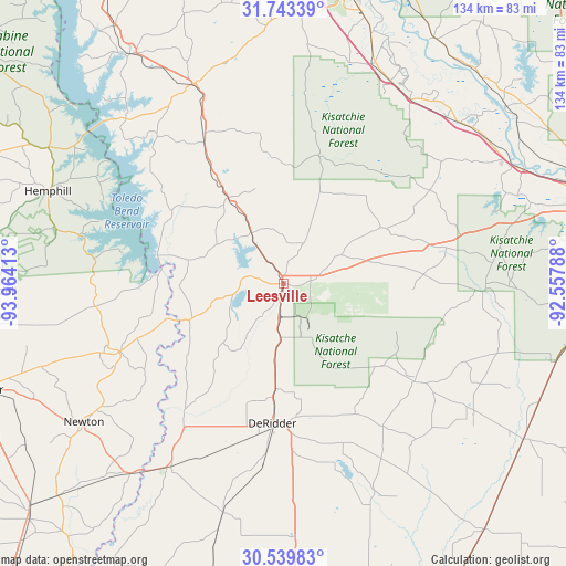
Leesville GPS coordinates[2]
31° 8' 36.672" North, 93° 15' 39.6" West
| Map corner | latitude | longitude |
|---|---|---|
| Upper-left | 31.74339°, | -93.96413° |
| Center: | 31.14352°, | -93.261° |
| Lower-right: | 30.53983°, | -92.55788° |
| Map W x H: | 133.8×133.8 km | = 83.1×83.1mi |
| max Lat: | 71.29058° ⇑90.4% North |
| Leesville: | 31.14352° |
| min Lat: | ⇓9.6% South 19.06759° |
| min Long | Leesville | max Long |
| -171.73463° | -93.261° | -66.98998° |
| W 33.1%⇐ | ⇒66.9% E |
Elevation
Elevation of Leesville is 81 m = 266 ft, and this is 213.8 m = 701 ft below average elevation for this country.
| Max E: |
3189 m = 10463 ft | 73.3% |
| Avg. | 294.8 m = 967 ft | |
| Leesville | 81 m = 266 ft | |
Min E: |
-60 m = -197 ft | 26.7% |
See also: United States elevation on elevation.city.
Geographical zone
Leesville is located in North temperate zone (between Tropic of Cancer and the Arctic Circle). Distance of this Northern Tropic circle is 856.9 km =532.5 mi to South.| Distance of | km | miles | from Leesville |
|---|---|---|---|
| North Pole | 6544.2 | 4066.4 | to North |
| Arctic Circle | 3938.3 | 2447.1 | to North |
| Tropic Cancer | 856.9 | 532.5 | to South |
| Equator | 3462.8 | 2151.7 | to South |


Nearby cities:
15 places around Leesville: (largest is in red/bold)
• Anacoco
14.3 km =8.9 mi,  327°
327°
• DeRidder
33.2 km =20.6 mi,  184°
184°
• Elizabeth
54.1 km =33.6 mi,  124°
124°
• Florien
38.2 km =23.7 mi, 330°
• Fort Jesup
53.9 km =33.5 mi,  345°
345°
• Fort Polk North
9 km =5.6 mi, 120°
• Fort Polk South
11.1 km =6.9 mi,  157°
157°
• Many
51.8 km =32.2 mi,  335°
335°
• Merryville
50.8 km =31.6 mi,  211°
211°
• New Llano
3.3 km =2.1 mi,  197°
197°
• Pitkin
38.6 km =24 mi,  126°
126°
• Provencal
56.9 km =35.4 mi,  5°
5°
• Rosepine
24.9 km =15.5 mi, 184°
• Simpson
26 km =16.2 mi,  64°
64°
• South Toledo Bend
32.7 km =20.3 mi,  271°
271°
Sources, notices
• [Note1] Compared only with cities in United States existing in our database
• [Src1] Map data: © OpenStreetMap contributors (CC-BY-SA)
• [Src2] Other city data from geonames.org with taken over terms of usage.
• [Src3] Geographical zone / Annual Mean Temperature by Robert A. Rohde @ Wikipedia
