Pitkin geodata
Pitkin (Louisiana) is a populated place; located in United States in America/Chicago (GMT-5) time zone. With population of 576 people, there are 19960 cities with bigger population in this country. Compared to other cities in United States, 90.8% of cities are located further ↑North; 66.1% of cities are located further →East and 77.3% of cities have higher elevation than Pitkin. Note1


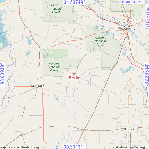
Pitkin GPS coordinates[2]
30° 56' 10.68" North, 92° 56' 10.536" West
| Map corner | latitude | longitude |
|---|---|---|
| Upper-left | 31.53749°, | -93.63939° |
| Center: | 30.9363°, | -92.93626° |
| Lower-right: | 30.33131°, | -92.23314° |
| Map W x H: | 134.1×134.1 km | = 83.3×83.3mi |
| max Lat: | 71.29058° ⇑90.8% North |
| Pitkin: | 30.9363° |
| min Lat: | ⇓9.2% South 19.06759° |
| min Long | Pitkin | max Long |
| -171.73463° | -92.93626° | -66.98998° |
| W 33.9%⇐ | ⇒66.1% E |
Elevation
Elevation of Pitkin is 59 m = 194 ft, and this is 235.8 m = 774 ft below average elevation for this country.
| Max E: |
3189 m = 10463 ft | 77.3% |
| Avg. | 294.8 m = 967 ft | |
| Pitkin | 59 m = 194 ft | |
Min E: |
-60 m = -197 ft | 22.7% |
See also: United States elevation on elevation.city.
Geographical zone
Pitkin is located in North temperate zone (between Tropic of Cancer and the Arctic Circle). Distance of this Northern Tropic circle is 833.9 km =518.2 mi to South.| Distance of | km | miles | from Pitkin |
|---|---|---|---|
| North Pole | 6567.3 | 4080.7 | to North |
| Arctic Circle | 3961.4 | 2461.5 | to North |
| Tropic Cancer | 833.9 | 518.2 | to South |
| Equator | 3439.8 | 2137.4 | to South |


Nearby cities:
15 places around Pitkin: (largest is in red/bold)
• DeRidder
35.1 km =21.8 mi,  253°
253°
• Elizabeth
15.6 km =9.7 mi,  118°
118°
• Forest Hill
40.3 km =25 mi,  73°
73°
• Fort Polk North
29.7 km =18.5 mi,  308°
308°
• Fort Polk South
29.5 km =18.3 mi,  295°
295°
• Glenmora
33.8 km =21 mi,  82°
82°
• Kinder
50.8 km =31.6 mi,  170°
170°
• Leesville
38.6 km =24 mi, 306°
• Longville
46.4 km =28.8 mi,  217°
217°
• New Llano
37.6 km =23.4 mi, 301°
• Oakdale
29.5 km =18.3 mi, 116°
• Oberlin
38.9 km =24.2 mi,  154°
154°
• Rosepine
33.1 km =20.6 mi,  266°
266°
• Simpson
35.2 km =21.9 mi,  347°
347°
• Woodworth
47.9 km =29.8 mi,  60°
60°
Sources, notices
• [Note1] Compared only with cities in United States existing in our database
• [Src1] Map data: © OpenStreetMap contributors (CC-BY-SA)
• [Src2] Other city data from geonames.org with taken over terms of usage.
• [Src3] Geographical zone / Annual Mean Temperature by Robert A. Rohde @ Wikipedia
