Fort Polk North geodata
Fort Polk North (Louisiana) is a populated place; located in United States in America/Chicago (GMT-5) time zone. With population of 2,864 people, there are 9886 cities with bigger population in this country. Compared to other cities in United States, 90.5% of cities are located further ↑North; 66.7% of cities are located further →East and 66.9% of cities have higher elevation than Fort Polk North. Note1


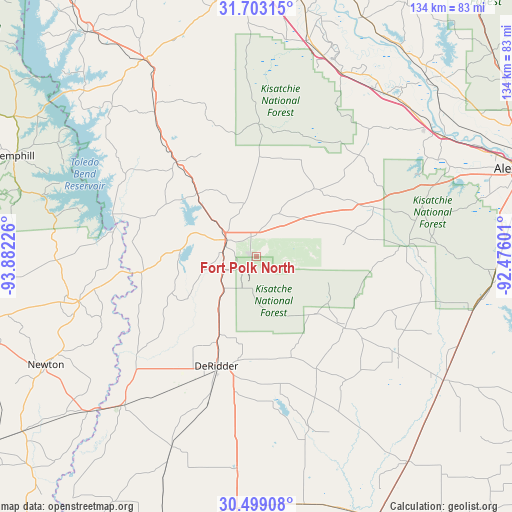
Fort Polk North GPS coordinates[2]
31° 6' 10.872" North, 93° 10' 44.868" West
| Map corner | latitude | longitude |
|---|---|---|
| Upper-left | 31.70315°, | -93.88226° |
| Center: | 31.10302°, | -93.17913° |
| Lower-right: | 30.49908°, | -92.47601° |
| Map W x H: | 133.9×133.9 km | = 83.2×83.2mi |
| max Lat: | 71.29058° ⇑90.5% North |
| Fort Polk North: | 31.10302° |
| min Lat: | ⇓9.5% South 19.06759° |
| min Long | Fort Polk North | max Long |
| -171.73463° | -93.17913° | -66.98998° |
| W 33.3%⇐ | ⇒66.7% E |
Elevation
Elevation of Fort Polk North is 118 m = 387 ft, and this is 176.8 m = 580 ft below average elevation for this country.
| Max E: |
3189 m = 10463 ft | 66.9% |
| Avg. | 294.8 m = 967 ft | |
| Fort Polk North | 118 m = 387 ft | |
Min E: |
-60 m = -197 ft | 33.1% |
See also: United States elevation on elevation.city.
Geographical zone
Fort Polk North is located in North temperate zone (between Tropic of Cancer and the Arctic Circle). Distance of this Northern Tropic circle is 852.4 km =529.7 mi to South.| Distance of | km | miles | from Fort Polk North |
|---|---|---|---|
| North Pole | 6548.7 | 4069.2 | to North |
| Arctic Circle | 3942.8 | 2449.9 | to North |
| Tropic Cancer | 852.4 | 529.7 | to South |
| Equator | 3458.3 | 2148.9 | to South |


Nearby cities:
15 places around Fort Polk North: (largest is in red/bold)
• Anacoco
22.6 km =14 mi,  317°
317°
• Boyce
58.1 km =36.1 mi,  56°
56°
• DeRidder
30.4 km =18.9 mi,  200°
200°
• Elizabeth
45.1 km =28 mi,  125°
125°
• Florien
46.2 km =28.7 mi,  325°
325°
• Fort Polk South
6.7 km =4.2 mi,  211°
211°
• Glenmora
58.3 km =36.2 mi,  103°
103°
• Leesville
9 km =5.6 mi,  300°
300°
• Longville
55.6 km =34.5 mi,  185°
185°
• Merryville
51.9 km =32.2 mi,  221°
221°
• New Llano
8.9 km =5.5 mi,  278°
278°
• Pitkin
29.7 km =18.5 mi, 128°
• Rosepine
22.6 km =14 mi, 205°
• Simpson
22.2 km =13.8 mi,  44°
44°
• South Toledo Bend
40.9 km =25.4 mi, 277°
Sources, notices
• [Note1] Compared only with cities in United States existing in our database
• [Src1] Map data: © OpenStreetMap contributors (CC-BY-SA)
• [Src2] Other city data from geonames.org with taken over terms of usage.
• [Src3] Geographical zone / Annual Mean Temperature by Robert A. Rohde @ Wikipedia
