La Plata geodata
La Plata (Maryland) is a seat of a second-order administrative division; located in United States in America/New_York (GMT-4) time zone. With population of 9,125 people, there are 4757 cities with bigger population in this country. Compared to other cities in United States, 58.6% of cities are located further ↑North; 80.7% of cities are located further ←West and 78.2% of cities have higher elevation than La Plata. Note1


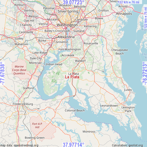
La Plata GPS coordinates[2]
38° 31' 45.444" North, 76° 58' 30.9" West
| Map corner | latitude | longitude |
|---|---|---|
| Upper-left | 39.07723°, | -77.67838° |
| Center: | 38.52929°, | -76.97525° |
| Lower-right: | 37.97714°, | -76.27213° |
| Map W x H: | 122.3×122.3 km | = 76×76mi |
| max Lat: | 71.29058° ⇑58.6% North |
| La Plata: | 38.52929° |
| min Lat: | ⇓41.4% South 19.06759° |
| min Long | La Plata | max Long |
| -171.73463° | -76.97525° | -66.98998° |
| W 80.7%⇐ | ⇒19.3% E |
Elevation
Elevation of La Plata is 55 m = 180 ft, and this is 239.8 m = 787 ft below average elevation for this country.
| Max E: |
3189 m = 10463 ft | 78.2% |
| Avg. | 294.8 m = 967 ft | |
| La Plata | 55 m = 180 ft | |
Min E: |
-60 m = -197 ft | 21.8% |
See also: United States elevation on elevation.city.
Geographical zone
La Plata is located in North temperate zone (between Tropic of Cancer and the Arctic Circle). Distance of this Northern Tropic circle is 1678.1 km =1042.7 mi to South.| Distance of | km | miles | from La Plata |
|---|---|---|---|
| North Pole | 5723 | 3556.1 | to North |
| Arctic Circle | 3117.1 | 1936.9 | to North |
| Tropic Cancer | 1678.1 | 1042.7 | to South |
| Equator | 4284.1 | 2662 | to South |


Nearby cities:
15 places around La Plata: (largest is in red/bold)
• Accokeek
16.1 km =10 mi,  343°
343°
• Bennsville
9.5 km =5.9 mi, 340°
• Brandywine
21.7 km =13.5 mi,  30°
30°
• Bryans Road
13.8 km =8.6 mi,  321°
321°
• Bryantown
11.9 km =7.4 mi,  76°
76°
• Cedarville
21.1 km =13.1 mi,  45°
45°
• Charlotte Hall
18 km =11.2 mi,  107°
107°
• Fort Washington
20.2 km =12.6 mi,  348°
348°
• Hughesville
16.7 km =10.4 mi,  88°
88°
• Indian Head
18.1 km =11.2 mi,  295°
295°
• Pomfret
7.2 km =4.5 mi, 318°
• Potomac Heights
16.9 km =10.5 mi, 301°
• Saint Charles
8.8 km =5.5 mi,  21°
21°
• St. Charles
9.7 km =6 mi, 26°
• Waldorf
11 km =6.8 mi, 16°
Sources, notices
• [Note1] Compared only with cities in United States existing in our database
• [Src1] Map data: © OpenStreetMap contributors (CC-BY-SA)
• [Src2] Other city data from geonames.org with taken over terms of usage.
• [Src3] Geographical zone / Annual Mean Temperature by Robert A. Rohde @ Wikipedia
