Reisterstown geodata
Reisterstown (Maryland) is a populated place; located in United States in America/New_York (GMT-4) time zone. With population of 25,968 people, there are 1930 cities with bigger population in this country. Compared to other cities in United States, 51.1% of cities are located further ↑North; 81.3% of cities are located further ←West and 55.4% of cities have lower elevation than Reisterstown. Note1


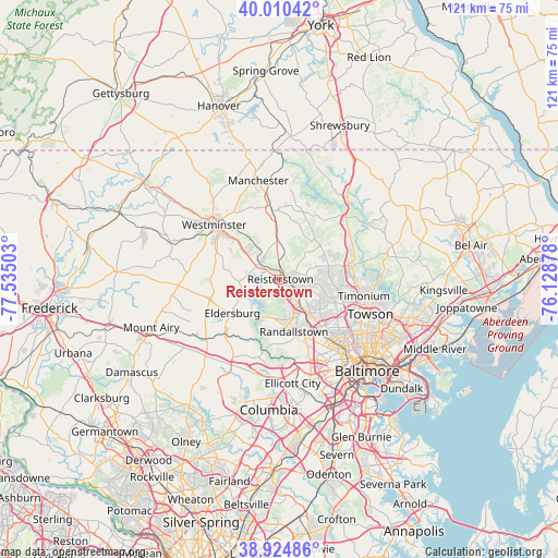
Reisterstown GPS coordinates[2]
39° 28' 11.136" North, 76° 49' 54.84" West
| Map corner | latitude | longitude |
|---|---|---|
| Upper-left | 40.01042°, | -77.53503° |
| Center: | 39.46976°, | -76.8319° |
| Lower-right: | 38.92486°, | -76.12878° |
| Map W x H: | 120.7×120.7 km | = 75×75mi |
| max Lat: | 71.29058° ⇑51.1% North |
| Reisterstown: | 39.46976° |
| min Lat: | ⇓48.9% South 19.06759° |
| min Long | Reisterstown | max Long |
| -171.73463° | -76.8319° | -66.98998° |
| W 81.3%⇐ | ⇒18.7% E |
Elevation
Elevation of Reisterstown is 220 m = 722 ft, and this is 74.8 m = 245 ft below average elevation for this country.
| Max E: |
3189 m = 10463 ft | 44.6% |
| Avg. | 294.8 m = 967 ft | |
| Reisterstown | 220 m = 722 ft | |
Min E: |
-60 m = -197 ft | 55.4% |
See also: United States elevation on elevation.city.
Geographical zone
Reisterstown is located in North temperate zone (between Tropic of Cancer and the Arctic Circle). Distance of this Northern Tropic circle is 1782.7 km =1107.7 mi to South.| Distance of | km | miles | from Reisterstown |
|---|---|---|---|
| North Pole | 5618.4 | 3491.1 | to North |
| Arctic Circle | 3012.5 | 1871.9 | to North |
| Tropic Cancer | 1782.7 | 1107.7 | to South |
| Equator | 4388.6 | 2726.9 | to South |


Nearby cities:
15 places around Reisterstown: (largest is in red/bold)
• Cockeysville
16.2 km =10.1 mi,  85°
85°
• Eldersburg
12.5 km =7.8 mi,  234°
234°
• Garrison
9.4 km =5.8 mi,  139°
139°
• Hampstead
15.1 km =9.4 mi,  354°
354°
• Hunt Valley
16.7 km =10.4 mi,  78°
78°
• Lochearn
17.2 km =10.7 mi,  146°
146°
• Lutherville
18.5 km =11.5 mi,  106°
106°
• Mays Chapel
16.2 km =10.1 mi,  104°
104°
• Milford Mill
14.6 km =9.1 mi,  158°
158°
• Owings Mills
7.1 km =4.4 mi, 141°
• Pikesville
14.2 km =8.8 mi, 138°
• Randallstown
11.8 km =7.3 mi, 164°
• Sykesville
15.8 km =9.8 mi, 227°
• Timonium
18.6 km =11.6 mi, 101°
• Westminster
18.3 km =11.4 mi,  309°
309°
Sources, notices
• [Note1] Compared only with cities in United States existing in our database
• [Src1] Map data: © OpenStreetMap contributors (CC-BY-SA)
• [Src2] Other city data from geonames.org with taken over terms of usage.
• [Src3] Geographical zone / Annual Mean Temperature by Robert A. Rohde @ Wikipedia
