Ashland geodata
Ashland (Missouri) is a populated place; located in United States in America/Chicago (GMT-5) time zone. With population of 3,865 people, there are 8373 cities with bigger population in this country. Compared to other cities in United States, 56.8% of cities are located further ↑North; 64.7% of cities are located further →East and 68.2% of cities have lower elevation than Ashland. Note1


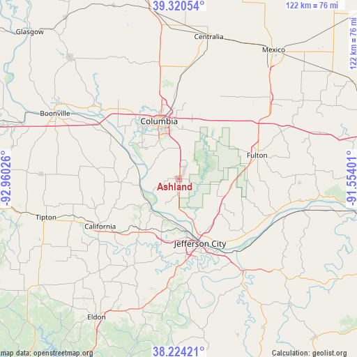
Ashland GPS coordinates[2]
38° 46' 28.128" North, 92° 15' 25.668" West
| Map corner | latitude | longitude |
|---|---|---|
| Upper-left | 39.32054°, | -92.96026° |
| Center: | 38.77448°, | -92.25713° |
| Lower-right: | 38.22421°, | -91.55401° |
| Map W x H: | 121.9×121.9 km | = 75.7×75.7mi |
| max Lat: | 71.29058° ⇑56.8% North |
| Ashland: | 38.77448° |
| min Lat: | ⇓43.2% South 19.06759° |
| min Long | Ashland | max Long |
| -171.73463° | -92.25713° | -66.98998° |
| W 35.3%⇐ | ⇒64.7% E |
Elevation
Elevation of Ashland is 277 m = 909 ft, and this is 17.8 m = 58 ft below average elevation for this country.
| Max E: |
3189 m = 10463 ft | 31.8% |
| Avg. | 294.8 m = 967 ft | |
| Ashland | 277 m = 909 ft | |
Min E: |
-60 m = -197 ft | 68.2% |
See also: United States elevation on elevation.city.
Geographical zone
Ashland is located in North temperate zone (between Tropic of Cancer and the Arctic Circle). Distance of this Northern Tropic circle is 1705.4 km =1059.7 mi to South.| Distance of | km | miles | from Ashland |
|---|---|---|---|
| North Pole | 5695.7 | 3539.1 | to North |
| Arctic Circle | 3089.9 | 1920 | to North |
| Tropic Cancer | 1705.4 | 1059.7 | to South |
| Equator | 4311.3 | 2678.9 | to South |


Nearby cities:
15 places around Ashland: (largest is in red/bold)
• Auxvasse
41.3 km =25.7 mi,  48°
48°
• Boonville
47.6 km =29.6 mi,  297°
297°
• California
31.4 km =19.5 mi,  238°
238°
• Columbia
20.8 km =12.9 mi,  341°
341°
• Fulton
28 km =17.4 mi,  73°
73°
• Hallsville
38.2 km =23.7 mi,  4°
4°
• Holts Summit
19 km =11.8 mi,  141°
141°
• Jefferson City
23.2 km =14.4 mi,  161°
161°
• Linn
47.7 km =29.6 mi,  132°
132°
• New Bloomfield
15.6 km =9.7 mi,  112°
112°
• Russellville
33.3 km =20.7 mi,  208°
208°
• Saint Martins
21.2 km =13.2 mi,  199°
199°
• Taos
33.9 km =21.1 mi,  151°
151°
• Tipton
47.2 km =29.3 mi,  253°
253°
• Wardsville
32.6 km =20.3 mi,  167°
167°
Sources, notices
• [Note1] Compared only with cities in United States existing in our database
• [Src1] Map data: © OpenStreetMap contributors (CC-BY-SA)
• [Src2] Other city data from geonames.org with taken over terms of usage.
• [Src3] Geographical zone / Annual Mean Temperature by Robert A. Rohde @ Wikipedia
