Auxvasse geodata
Auxvasse (Missouri) is a populated place; located in United States in America/Chicago (GMT-5) time zone. With population of 985 people, there are 16374 cities with bigger population in this country. Compared to other cities in United States, 54.7% of cities are located further ↑North; 63.9% of cities are located further →East and 66.6% of cities have lower elevation than Auxvasse. Note1


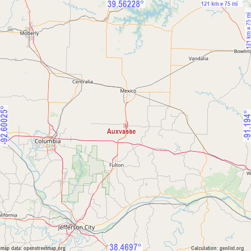
Auxvasse GPS coordinates[2]
39° 1' 5.16" North, 91° 53' 49.632" West
| Map corner | latitude | longitude |
|---|---|---|
| Upper-left | 39.56228°, | -92.60025° |
| Center: | 39.0181°, | -91.89712° |
| Lower-right: | 38.4697°, | -91.194° |
| Map W x H: | 121.5×121.5 km | = 75.5×75.5mi |
| max Lat: | 71.29058° ⇑54.7% North |
| Auxvasse: | 39.0181° |
| min Lat: | ⇓45.3% South 19.06759° |
| min Long | Auxvasse | max Long |
| -171.73463° | -91.89712° | -66.98998° |
| W 36.1%⇐ | ⇒63.9% E |
Elevation
Elevation of Auxvasse is 269 m = 883 ft, and this is 25.8 m = 85 ft below average elevation for this country.
| Max E: |
3189 m = 10463 ft | 33.4% |
| Avg. | 294.8 m = 967 ft | |
| Auxvasse | 269 m = 883 ft | |
Min E: |
-60 m = -197 ft | 66.6% |
See also: United States elevation on elevation.city.
Geographical zone
Auxvasse is located in North temperate zone (between Tropic of Cancer and the Arctic Circle). Distance of this Northern Tropic circle is 1732.5 km =1076.5 mi to South.| Distance of | km | miles | from Auxvasse |
|---|---|---|---|
| North Pole | 5668.7 | 3522.4 | to North |
| Arctic Circle | 3062.8 | 1903.1 | to North |
| Tropic Cancer | 1732.5 | 1076.5 | to South |
| Equator | 4338.4 | 2695.8 | to South |


Nearby cities:
15 places around Auxvasse: (largest is in red/bold)
• Ashland
41.3 km =25.7 mi,  228°
228°
• Centralia
29.8 km =18.5 mi,  315°
315°
• Columbia
38.5 km =23.9 mi,  258°
258°
• Fulton
19.6 km =12.2 mi,  192°
192°
• Hallsville
30 km =18.6 mi,  291°
291°
• Holts Summit
46.3 km =28.8 mi,  204°
204°
• Laddonia
33.1 km =20.6 mi,  41°
41°
• Mexico
16.9 km =10.5 mi,  4°
4°
• Montgomery City
34.2 km =21.3 mi,  97°
97°
• New Bloomfield
37.1 km =23.1 mi,  206°
206°
• New Florence
40.6 km =25.2 mi,  107°
107°
• Perry
49.7 km =30.9 mi,  22°
22°
• Sturgeon
40.9 km =25.4 mi,  305°
305°
• Vandalia
48 km =29.8 mi,  47°
47°
• Wellsville
28.9 km =18 mi,  78°
78°
Sources, notices
• [Note1] Compared only with cities in United States existing in our database
• [Src1] Map data: © OpenStreetMap contributors (CC-BY-SA)
• [Src2] Other city data from geonames.org with taken over terms of usage.
• [Src3] Geographical zone / Annual Mean Temperature by Robert A. Rohde @ Wikipedia
