Columbia geodata
Columbia (Missouri) is a seat of a second-order administrative division; located in United States in America/Chicago (GMT-5) time zone. With population of 119,108 people, there are 264 cities with bigger population in this country. Compared to other cities in United States, 55.4% of cities are located further ↑North; 64.8% of cities are located further →East and 55.1% of cities have lower elevation than Columbia. Note1


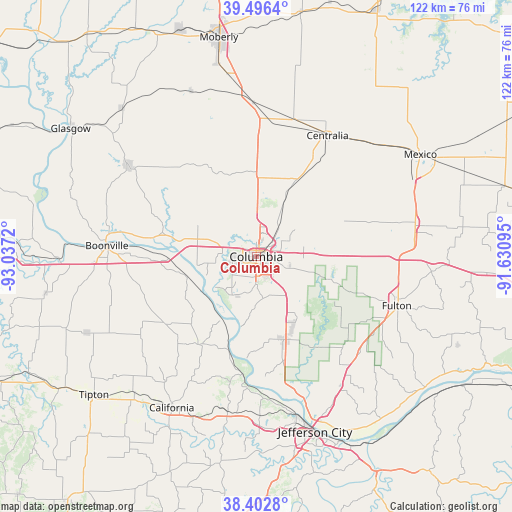
Columbia GPS coordinates[2]
38° 57' 6.156" North, 92° 20' 2.652" West
| Map corner | latitude | longitude |
|---|---|---|
| Upper-left | 39.4964°, | -93.0372° |
| Center: | 38.95171°, | -92.33407° |
| Lower-right: | 38.4028°, | -91.63095° |
| Map W x H: | 121.6×121.6 km | = 75.6×75.6mi |
| max Lat: | 71.29058° ⇑55.4% North |
| Columbia: | 38.95171° |
| min Lat: | ⇓44.6% South 19.06759° |
| min Long | Columbia | max Long |
| -171.73463° | -92.33407° | -66.98998° |
| W 35.2%⇐ | ⇒64.8% E |
Elevation
Elevation of Columbia is 219 m = 719 ft, and this is 75.8 m = 249 ft below average elevation for this country.
| Max E: |
3189 m = 10463 ft | 44.9% |
| Avg. | 294.8 m = 967 ft | |
| Columbia | 219 m = 719 ft | |
Min E: |
-60 m = -197 ft | 55.1% |
See also: Columbia elevation on elevation.city.
Geographical zone
Columbia is located in North temperate zone (between Tropic of Cancer and the Arctic Circle). Distance of this Northern Tropic circle is 1725.1 km =1071.9 mi to South.| Distance of | km | miles | from Columbia |
|---|---|---|---|
| North Pole | 5676 | 3526.9 | to North |
| Arctic Circle | 3070.1 | 1907.7 | to North |
| Tropic Cancer | 1725.1 | 1071.9 | to South |
| Equator | 4331 | 2691.2 | to South |


Nearby cities:
15 places around Columbia: (largest is in red/bold)
• Ashland
20.8 km =12.9 mi,  161°
161°
• Auxvasse
38.5 km =23.9 mi,  78°
78°
• Boonville
35.5 km =22.1 mi,  273°
273°
• California
41.3 km =25.7 mi,  209°
209°
• Centralia
33.4 km =20.8 mi,  30°
30°
• Fayette
37.1 km =23.1 mi,  305°
305°
• Fulton
35.4 km =22 mi,  109°
109°
• Hallsville
20.8 km =12.9 mi, 28°
• Higbee
42.2 km =26.2 mi,  338°
338°
• Holts Summit
39.2 km =24.4 mi,  152°
152°
• Jefferson City
44 km =27.3 mi, 161°
• New Bloomfield
33.2 km =20.6 mi,  140°
140°
• New Franklin
35.6 km =22.1 mi,  281°
281°
• Saint Martins
39.8 km =24.7 mi,  180°
180°
• Sturgeon
31.7 km =19.7 mi,  8°
8°
Sources, notices
• [Note1] Compared only with cities in United States existing in our database
• [Src1] Map data: © OpenStreetMap contributors (CC-BY-SA)
• [Src2] Other city data from geonames.org with taken over terms of usage.
• [Src3] Geographical zone / Annual Mean Temperature by Robert A. Rohde @ Wikipedia
