Centralia geodata
Centralia (Missouri) is a populated place; located in United States in America/Chicago (GMT-5) time zone. With population of 4,194 people, there are 7992 cities with bigger population in this country. Compared to other cities in United States, 53% of cities are located further ↑North; 64.4% of cities are located further →East and 67.2% of cities have lower elevation than Centralia. Note1


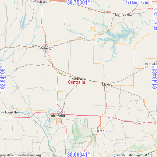
Centralia GPS coordinates[2]
39° 12' 37.152" North, 92° 8' 16.62" West
| Map corner | latitude | longitude |
|---|---|---|
| Upper-left | 39.75301°, | -92.84108° |
| Center: | 39.21032°, | -92.13795° |
| Lower-right: | 38.66341°, | -91.43483° |
| Map W x H: | 121.2×121.2 km | = 75.3×75.3mi |
| max Lat: | 71.29058° ⇑53% North |
| Centralia: | 39.21032° |
| min Lat: | ⇓47% South 19.06759° |
| min Long | Centralia | max Long |
| -171.73463° | -92.13795° | -66.98998° |
| W 35.6%⇐ | ⇒64.4% E |
Elevation
Elevation of Centralia is 272 m = 892 ft, and this is 22.8 m = 75 ft below average elevation for this country.
| Max E: |
3189 m = 10463 ft | 32.8% |
| Avg. | 294.8 m = 967 ft | |
| Centralia | 272 m = 892 ft | |
Min E: |
-60 m = -197 ft | 67.2% |
See also: United States elevation on elevation.city.
Geographical zone
Centralia is located in North temperate zone (between Tropic of Cancer and the Arctic Circle). Distance of this Northern Tropic circle is 1753.9 km =1089.8 mi to South.| Distance of | km | miles | from Centralia |
|---|---|---|---|
| North Pole | 5647.3 | 3509.1 | to North |
| Arctic Circle | 3041.4 | 1889.8 | to North |
| Tropic Cancer | 1753.9 | 1089.8 | to South |
| Equator | 4359.8 | 2709.1 | to South |


Nearby cities:
15 places around Centralia: (largest is in red/bold)
• Ashland
49.5 km =30.8 mi,  191°
191°
• Auxvasse
29.8 km =18.5 mi,  135°
135°
• Columbia
33.4 km =20.8 mi,  210°
210°
• Fayette
47.6 km =29.6 mi,  261°
261°
• Fulton
43.6 km =27.1 mi,  157°
157°
• Hallsville
12.6 km =7.8 mi, 214°
• Higbee
33.9 km =21.1 mi,  288°
288°
• Huntsville
43.4 km =27 mi,  306°
306°
• Laddonia
42.6 km =26.5 mi,  85°
85°
• Madison
29.9 km =18.6 mi,  348°
348°
• Mexico
22.4 km =13.9 mi,  101°
101°
• Moberly
34.7 km =21.6 mi, 311°
• Paris
32.3 km =20.1 mi,  21°
21°
• Perry
46.8 km =29.1 mi,  58°
58°
• Sturgeon
12.6 km =7.8 mi,  282°
282°
Sources, notices
• [Note1] Compared only with cities in United States existing in our database
• [Src1] Map data: © OpenStreetMap contributors (CC-BY-SA)
• [Src2] Other city data from geonames.org with taken over terms of usage.
• [Src3] Geographical zone / Annual Mean Temperature by Robert A. Rohde @ Wikipedia
