Eolia geodata
Eolia (Missouri) is a populated place; located in United States in America/Chicago (GMT-5) time zone. With population of 512 people, there are 20730 cities with bigger population in this country. Compared to other cities in United States, 52.7% of cities are located further ↑North; 62.1% of cities are located further →East and 64.3% of cities have lower elevation than Eolia. Note1
Administrative division(s):
- Level 1: Missouri
- Level 2: Pike County
- Level 3: Township of Prairieville


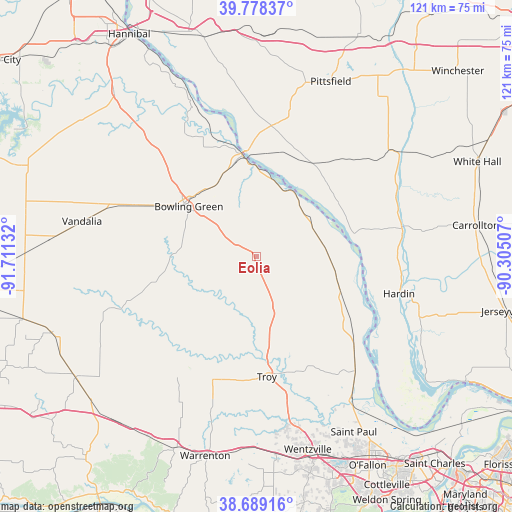
Eolia GPS coordinates[2]
39° 14' 9.168" North, 91° 0' 29.484" West
| Map corner | latitude | longitude |
|---|---|---|
| Upper-left | 39.77837°, | -91.71132° |
| Center: | 39.23588°, | -91.00819° |
| Lower-right: | 38.68916°, | -90.30507° |
| Map W x H: | 121.1×121.1 km | = 75.2×75.2mi |
| max Lat: | 71.29058° ⇑52.7% North |
| Eolia: | 39.23588° |
| min Lat: | ⇓47.3% South 19.06759° |
| min Long | Eolia | max Long |
| -171.73463° | -91.00819° | -66.98998° |
| W 37.9%⇐ | ⇒62.1% E |
Elevation
Elevation of Eolia is 259 m = 850 ft, and this is 35.8 m = 117 ft below average elevation for this country.
| Max E: |
3189 m = 10463 ft | 35.7% |
| Avg. | 294.8 m = 967 ft | |
| Eolia | 259 m = 850 ft | |
Min E: |
-60 m = -197 ft | 64.3% |
See also: United States elevation on elevation.city.
Geographical zone
Eolia is located in North temperate zone (between Tropic of Cancer and the Arctic Circle). Distance of this Northern Tropic circle is 1756.7 km =1091.6 mi to South.| Distance of | km | miles | from Eolia |
|---|---|---|---|
| North Pole | 5644.4 | 3507.3 | to North |
| Arctic Circle | 3038.6 | 1888.1 | to North |
| Tropic Cancer | 1756.7 | 1091.6 | to South |
| Equator | 4362.6 | 2710.8 | to South |


Nearby cities:
15 places around Eolia: (largest is in red/bold)
• Bowling Green
20 km =12.4 mi,  306°
306°
• Elsberry
21 km =13 mi,  111°
111°
• Flint Hill
44.2 km =27.5 mi,  163°
163°
• Foristell
47 km =29.2 mi,  174°
174°
• Hardin
34.8 km =21.6 mi,  104°
104°
• Hawk Point
31.3 km =19.4 mi,  199°
199°
• Louisiana
24 km =14.9 mi,  351°
351°
• Moscow Mills
33 km =20.5 mi, 166°
• Pittsfield
44.9 km =27.9 mi,  22°
22°
• Pleasant Hill
25.9 km =16.1 mi,  26°
26°
• Saint Paul
47.6 km =29.6 mi,  151°
151°
• Troy
28.6 km =17.8 mi,  175°
175°
• Vandalia
42.2 km =26.2 mi,  281°
281°
• Winfield
35.3 km =21.9 mi,  138°
138°
• Wright City
45.4 km =28.2 mi, 181°
Sources, notices
• [Note1] Compared only with cities in United States existing in our database
• [Src1] Map data: © OpenStreetMap contributors (CC-BY-SA)
• [Src2] Other city data from geonames.org with taken over terms of usage.
• [Src3] Geographical zone / Annual Mean Temperature by Robert A. Rohde @ Wikipedia
