Troy geodata
Troy (Missouri) is a seat of a second-order administrative division; located in United States in America/Chicago (GMT-5) time zone. With population of 11,542 people, there are 4011 cities with bigger population in this country. Compared to other cities in United States, 55.1% of cities are located further ↑North; 62% of cities are located further →East and 58.4% of cities have higher elevation than Troy. Note1


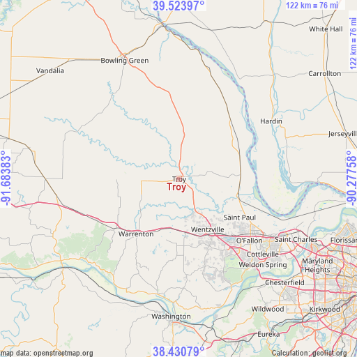
Troy GPS coordinates[2]
38° 58' 46.164" North, 90° 58' 50.52" West
| Map corner | latitude | longitude |
|---|---|---|
| Upper-left | 39.52397°, | -91.68383° |
| Center: | 38.97949°, | -90.9807° |
| Lower-right: | 38.43079°, | -90.27758° |
| Map W x H: | 121.6×121.5 km | = 75.6×75.5mi |
| max Lat: | 71.29058° ⇑55.1% North |
| Troy: | 38.97949° |
| min Lat: | ⇓44.9% South 19.06759° |
| min Long | Troy | max Long |
| -171.73463° | -90.9807° | -66.98998° |
| W 38%⇐ | ⇒62% E |
Elevation
Elevation of Troy is 163 m = 535 ft, and this is 131.8 m = 432 ft below average elevation for this country.
| Max E: |
3189 m = 10463 ft | 58.4% |
| Avg. | 294.8 m = 967 ft | |
| Troy | 163 m = 535 ft | |
Min E: |
-60 m = -197 ft | 41.6% |
See also: United States elevation on elevation.city.
Geographical zone
Troy is located in North temperate zone (between Tropic of Cancer and the Arctic Circle). Distance of this Northern Tropic circle is 1728.2 km =1073.9 mi to South.| Distance of | km | miles | from Troy |
|---|---|---|---|
| North Pole | 5672.9 | 3525 | to North |
| Arctic Circle | 3067.1 | 1905.8 | to North |
| Tropic Cancer | 1728.2 | 1073.9 | to South |
| Equator | 4334.1 | 2693.1 | to South |


Nearby cities:
15 places around Troy: (largest is in red/bold)
• Elsberry
27 km =16.8 mi,  39°
39°
• Eolia
28.6 km =17.8 mi,  355°
355°
• Flint Hill
17.3 km =10.7 mi,  143°
143°
• Foristell
18.4 km =11.4 mi,  173°
173°
• Hawk Point
13 km =8.1 mi,  265°
265°
• Innsbrook
24.2 km =15 mi,  194°
194°
• Lake Saint Louis
26.3 km =16.3 mi, 140°
• Moscow Mills
6.4 km =4 mi,  123°
123°
• O'Fallon
30.7 km =19.1 mi,  127°
127°
• Saint Paul
24.5 km =15.2 mi, 122°
• Truesdale
22.7 km =14.1 mi,  214°
214°
• Warrenton
23.3 km =14.5 mi,  216°
216°
• Wentzville
21.7 km =13.5 mi,  149°
149°
• Winfield
21 km =13 mi,  84°
84°
• Wright City
17.2 km =10.7 mi, 191°
Sources, notices
• [Note1] Compared only with cities in United States existing in our database
• [Src1] Map data: © OpenStreetMap contributors (CC-BY-SA)
• [Src2] Other city data from geonames.org with taken over terms of usage.
• [Src3] Geographical zone / Annual Mean Temperature by Robert A. Rohde @ Wikipedia
