De Soto geodata
De Soto (Missouri) is a populated place; located in United States in America/Chicago (GMT-5) time zone. With population of 6,495 people, there are 6113 cities with bigger population in this country. Compared to other cities in United States, 60.9% of cities are located further ↑North; 61% of cities are located further →East and 57.8% of cities have higher elevation than De Soto. Note1


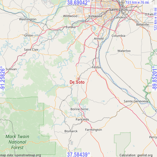
De Soto GPS coordinates[2]
38° 8' 22.2" North, 90° 33' 18.468" West
| Map corner | latitude | longitude |
|---|---|---|
| Upper-left | 38.69042°, | -91.25826° |
| Center: | 38.1395°, | -90.55513° |
| Lower-right: | 37.58439°, | -89.85201° |
| Map W x H: | 123×123 km | = 76.4×76.4mi |
| max Lat: | 71.29058° ⇑60.9% North |
| De Soto: | 38.1395° |
| min Lat: | ⇓39.1% South 19.06759° |
| min Long | De Soto | max Long |
| -171.73463° | -90.55513° | -66.98998° |
| W 39%⇐ | ⇒61% E |
Elevation
Elevation of De Soto is 166 m = 545 ft, and this is 128.8 m = 423 ft below average elevation for this country.
| Max E: |
3189 m = 10463 ft | 57.8% |
| Avg. | 294.8 m = 967 ft | |
| De Soto | 166 m = 545 ft | |
Min E: |
-60 m = -197 ft | 42.2% |
See also: United States elevation on elevation.city.
Geographical zone
De Soto is located in North temperate zone (between Tropic of Cancer and the Arctic Circle). Distance of this Northern Tropic circle is 1634.8 km =1015.8 mi to South.| Distance of | km | miles | from De Soto |
|---|---|---|---|
| North Pole | 5766.3 | 3583 | to North |
| Arctic Circle | 3160.5 | 1963.8 | to North |
| Tropic Cancer | 1634.8 | 1015.8 | to South |
| Equator | 4240.7 | 2635 | to South |


Nearby cities:
15 places around De Soto: (largest is in red/bold)
• Barnhart
26.8 km =16.7 mi,  31°
31°
• Bonne Terre
24.1 km =15 mi,  180°
180°
• Cedar Hill
24.9 km =15.5 mi,  342°
342°
• Crystal City
17.9 km =11.1 mi,  59°
59°
• Desloge
30 km =18.6 mi, 175°
• Festus
16.6 km =10.3 mi, 57°
• Herculaneum
21 km =13 mi,  46°
46°
• Hillsboro
10.3 km =6.4 mi,  356°
356°
• Horine
18.2 km =11.3 mi,  38°
38°
• Imperial
29.9 km =18.6 mi, 31°
• Olympian Village
8.5 km =5.3 mi,  92°
92°
• Pevely
21.2 km =13.2 mi, 41°
• Potosi
30.4 km =18.9 mi,  222°
222°
• Riverside
22.4 km =13.9 mi, 43°
• Terre du Lac
26.1 km =16.2 mi,  193°
193°
Sources, notices
• [Note1] Compared only with cities in United States existing in our database
• [Src1] Map data: © OpenStreetMap contributors (CC-BY-SA)
• [Src2] Other city data from geonames.org with taken over terms of usage.
• [Src3] Geographical zone / Annual Mean Temperature by Robert A. Rohde @ Wikipedia
