Hillsboro geodata
Hillsboro (Missouri) is a seat of a second-order administrative division; located in United States in America/Chicago (GMT-5) time zone. With population of 3,076 people, there are 9506 cities with bigger population in this country. Compared to other cities in United States, 60.4% of cities are located further ↑North; 61.1% of cities are located further →East and 59.6% of cities have lower elevation than Hillsboro. Note1
Administrative division(s):
- Level 1: Missouri
- Level 2: Jefferson County
- Level 3: Township of Central


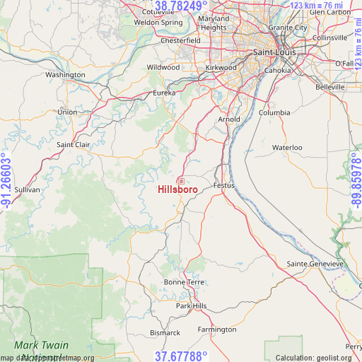
Hillsboro GPS coordinates[2]
38° 13' 56.208" North, 90° 33' 46.44" West
| Map corner | latitude | longitude |
|---|---|---|
| Upper-left | 38.78249°, | -91.26603° |
| Center: | 38.23228°, | -90.5629° |
| Lower-right: | 37.67788°, | -89.85978° |
| Map W x H: | 122.8×122.8 km | = 76.3×76.3mi |
| max Lat: | 71.29058° ⇑60.4% North |
| Hillsboro: | 38.23228° |
| min Lat: | ⇓39.6% South 19.06759° |
| min Long | Hillsboro | max Long |
| -171.73463° | -90.5629° | -66.98998° |
| W 38.9%⇐ | ⇒61.1% E |
Elevation
Elevation of Hillsboro is 238 m = 781 ft, and this is 56.8 m = 186 ft below average elevation for this country.
| Max E: |
3189 m = 10463 ft | 40.4% |
| Avg. | 294.8 m = 967 ft | |
| Hillsboro | 238 m = 781 ft | |
Min E: |
-60 m = -197 ft | 59.6% |
See also: United States elevation on elevation.city.
Geographical zone
Hillsboro is located in North temperate zone (between Tropic of Cancer and the Arctic Circle). Distance of this Northern Tropic circle is 1645.1 km =1022.2 mi to South.| Distance of | km | miles | from Hillsboro |
|---|---|---|---|
| North Pole | 5756 | 3576.6 | to North |
| Arctic Circle | 3150.1 | 1957.4 | to North |
| Tropic Cancer | 1645.1 | 1022.2 | to South |
| Equator | 4251 | 2641.4 | to South |


Nearby cities:
15 places around Hillsboro: (largest is in red/bold)
• Barnhart
19.3 km =12 mi,  49°
49°
• Byrnes Mill
22.9 km =14.2 mi,  355°
355°
• Cedar Hill
15.1 km =9.4 mi,  333°
333°
• Crystal City
16.1 km =10 mi,  94°
94°
• De Soto
10.3 km =6.4 mi,  176°
176°
• Festus
14.6 km =9.1 mi,  95°
95°
• Herculaneum
16.5 km =10.3 mi,  75°
75°
• High Ridge
25.3 km =15.7 mi,  5°
5°
• Horine
12.7 km =7.9 mi,  72°
72°
• Imperial
22.2 km =13.8 mi, 46°
• LaBarque Creek
22.9 km =14.2 mi, 333°
• Olympian Village
14.1 km =8.8 mi,  139°
139°
• Pevely
15.7 km =9.8 mi, 68°
• Riverside
17.1 km =10.6 mi, 69°
• Valmeyer
26.3 km =16.3 mi, 71°
Sources, notices
• [Note1] Compared only with cities in United States existing in our database
• [Src1] Map data: © OpenStreetMap contributors (CC-BY-SA)
• [Src2] Other city data from geonames.org with taken over terms of usage.
• [Src3] Geographical zone / Annual Mean Temperature by Robert A. Rohde @ Wikipedia
