Foristell geodata
Foristell (Missouri) is a populated place; located in United States in America/Chicago (GMT-5) time zone. With population of 520 people, there are 20628 cities with bigger population in this country. Compared to other cities in United States, 56.4% of cities are located further ↑North; 62% of cities are located further →East and 53.9% of cities have lower elevation than Foristell. Note1
Administrative division(s):
- Level 1: Missouri
- Level 2: Saint Charles County
- Level 3: Township of Boone


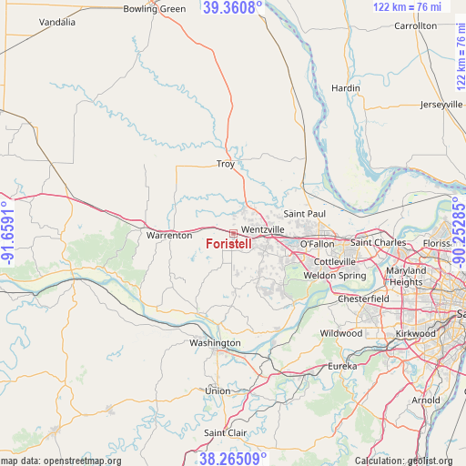
Foristell GPS coordinates[2]
38° 48' 54.18" North, 90° 57' 21.492" West
| Map corner | latitude | longitude |
|---|---|---|
| Upper-left | 39.3608°, | -91.6591° |
| Center: | 38.81505°, | -90.95597° |
| Lower-right: | 38.26509°, | -90.25285° |
| Map W x H: | 121.8×121.8 km | = 75.7×75.7mi |
| max Lat: | 71.29058° ⇑56.4% North |
| Foristell: | 38.81505° |
| min Lat: | ⇓43.6% South 19.06759° |
| min Long | Foristell | max Long |
| -171.73463° | -90.95597° | -66.98998° |
| W 38%⇐ | ⇒62% E |
Elevation
Elevation of Foristell is 214 m = 702 ft, and this is 80.8 m = 265 ft below average elevation for this country.
| Max E: |
3189 m = 10463 ft | 46.1% |
| Avg. | 294.8 m = 967 ft | |
| Foristell | 214 m = 702 ft | |
Min E: |
-60 m = -197 ft | 53.9% |
See also: United States elevation on elevation.city.
Geographical zone
Foristell is located in North temperate zone (between Tropic of Cancer and the Arctic Circle). Distance of this Northern Tropic circle is 1709.9 km =1062.5 mi to South.| Distance of | km | miles | from Foristell |
|---|---|---|---|
| North Pole | 5691.2 | 3536.3 | to North |
| Arctic Circle | 3085.3 | 1917.1 | to North |
| Tropic Cancer | 1709.9 | 1062.5 | to South |
| Equator | 4315.8 | 2681.7 | to South |


Nearby cities:
15 places around Foristell: (largest is in red/bold)
• Dardenne Prairie
20.3 km =12.6 mi,  104°
104°
• Flint Hill
9.3 km =5.8 mi,  61°
61°
• Hawk Point
23 km =14.3 mi,  318°
318°
• Innsbrook
9.8 km =6.1 mi,  238°
238°
• Lake Saint Louis
14.9 km =9.3 mi, 97°
• Marthasville
22.6 km =14 mi,  203°
203°
• Moscow Mills
15.1 km =9.4 mi,  12°
12°
• O'Fallon
22.2 km =13.8 mi,  91°
91°
• Saint Paul
19.3 km =12 mi,  74°
74°
• Troy
18.4 km =11.4 mi,  353°
353°
• Truesdale
15.1 km =9.4 mi,  268°
268°
• Warrenton
16.1 km =10 mi, 268°
• Weldon Spring
25.7 km =16 mi,  116°
116°
• Wentzville
8.9 km =5.5 mi, 92°
• Wright City
5.7 km =3.5 mi,  284°
284°
Sources, notices
• [Note1] Compared only with cities in United States existing in our database
• [Src1] Map data: © OpenStreetMap contributors (CC-BY-SA)
• [Src2] Other city data from geonames.org with taken over terms of usage.
• [Src3] Geographical zone / Annual Mean Temperature by Robert A. Rohde @ Wikipedia
