Batesville geodata
Batesville (Mississippi) is a populated place; located in United States in America/Chicago (GMT-5) time zone. With population of 7,385 people, there are 5606 cities with bigger population in this country. Compared to other cities in United States, 78.4% of cities are located further ↑North; 58.8% of cities are located further →East and 74.2% of cities have higher elevation than Batesville. Note1


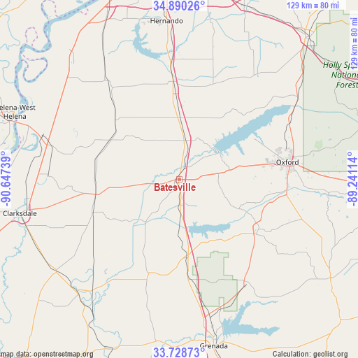
Batesville GPS coordinates[2]
34° 18' 41.4" North, 89° 56' 39.336" West
| Map corner | latitude | longitude |
|---|---|---|
| Upper-left | 34.89026°, | -90.64739° |
| Center: | 34.3115°, | -89.94426° |
| Lower-right: | 33.72873°, | -89.24114° |
| Map W x H: | 129.2×129.2 km | = 80.3×80.3mi |
| max Lat: | 71.29058° ⇑78.4% North |
| Batesville: | 34.3115° |
| min Lat: | ⇓21.6% South 19.06759° |
| min Long | Batesville | max Long |
| -171.73463° | -89.94426° | -66.98998° |
| W 41.2%⇐ | ⇒58.8% E |
Elevation
Elevation of Batesville is 76 m = 249 ft, and this is 218.8 m = 718 ft below average elevation for this country.
| Max E: |
3189 m = 10463 ft | 74.2% |
| Avg. | 294.8 m = 967 ft | |
| Batesville | 76 m = 249 ft | |
Min E: |
-60 m = -197 ft | 25.8% |
See also: United States elevation on elevation.city.
Geographical zone
Batesville is located in North temperate zone (between Tropic of Cancer and the Arctic Circle). Distance of this Northern Tropic circle is 1209.2 km =751.4 mi to South.| Distance of | km | miles | from Batesville |
|---|---|---|---|
| North Pole | 6192 | 3847.5 | to North |
| Arctic Circle | 3586.1 | 2228.3 | to North |
| Tropic Cancer | 1209.2 | 751.4 | to South |
| Equator | 3815.1 | 2370.6 | to South |


Nearby cities:
15 places around Batesville: (largest is in red/bold)
• Charleston
35.4 km =22 mi,  196°
196°
• Coldwater
42.4 km =26.3 mi,  355°
355°
• Como
22.1 km =13.7 mi,  1°
1°
• Courtland
7.8 km =4.8 mi,  179°
179°
• Crenshaw
31.6 km =19.6 mi,  312°
312°
• Crowder
23.5 km =14.6 mi,  229°
229°
• Lambert
33.5 km =20.8 mi,  248°
248°
• Marks
30.8 km =19.1 mi,  258°
258°
• Oakland
28.6 km =17.8 mi,  174°
174°
• Oxford
39.5 km =24.5 mi,  81°
81°
• Sardis
14.2 km =8.8 mi,  10°
10°
• Senatobia
34.1 km =21.2 mi, 356°
• Sledge
28.7 km =17.8 mi,  297°
297°
• University
38.9 km =24.2 mi, 81°
• Water Valley
33.8 km =21 mi,  121°
121°
Sources, notices
• [Note1] Compared only with cities in United States existing in our database
• [Src1] Map data: © OpenStreetMap contributors (CC-BY-SA)
• [Src2] Other city data from geonames.org with taken over terms of usage.
• [Src3] Geographical zone / Annual Mean Temperature by Robert A. Rohde @ Wikipedia
