Senatobia geodata
Senatobia (Mississippi) is a seat of a second-order administrative division; located in United States in America/Chicago (GMT-5) time zone. With population of 7,963 people, there are 5299 cities with bigger population in this country. Compared to other cities in United States, 77.2% of cities are located further ↑North; 58.9% of cities are located further →East and 72.3% of cities have higher elevation than Senatobia. Note1


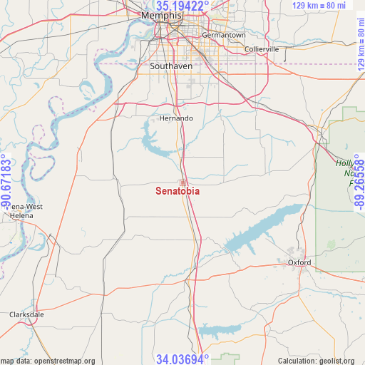
Senatobia GPS coordinates[2]
34° 37' 3.36" North, 89° 58' 7.32" West
| Map corner | latitude | longitude |
|---|---|---|
| Upper-left | 35.19422°, | -90.67183° |
| Center: | 34.6176°, | -89.9687° |
| Lower-right: | 34.03694°, | -89.26558° |
| Map W x H: | 128.7×128.7 km | = 80×80mi |
| max Lat: | 71.29058° ⇑77.2% North |
| Senatobia: | 34.6176° |
| min Lat: | ⇓22.8% South 19.06759° |
| min Long | Senatobia | max Long |
| -171.73463° | -89.9687° | -66.98998° |
| W 41.1%⇐ | ⇒58.9% E |
Elevation
Elevation of Senatobia is 87 m = 285 ft, and this is 207.8 m = 682 ft below average elevation for this country.
| Max E: |
3189 m = 10463 ft | 72.3% |
| Avg. | 294.8 m = 967 ft | |
| Senatobia | 87 m = 285 ft | |
Min E: |
-60 m = -197 ft | 27.7% |
See also: United States elevation on elevation.city.
Geographical zone
Senatobia is located in North temperate zone (between Tropic of Cancer and the Arctic Circle). Distance of this Northern Tropic circle is 1243.2 km =772.5 mi to South.| Distance of | km | miles | from Senatobia |
|---|---|---|---|
| North Pole | 6157.9 | 3826.3 | to North |
| Arctic Circle | 3552.1 | 2207.2 | to North |
| Tropic Cancer | 1243.2 | 772.5 | to South |
| Equator | 3849.1 | 2391.7 | to South |


Nearby cities:
15 places around Senatobia: (largest is in red/bold)
• Batesville
34.1 km =21.2 mi,  176°
176°
• Byhalia
38 km =23.6 mi,  41°
41°
• Coldwater
8.3 km =5.2 mi,  354°
354°
• Como
12.2 km =7.6 mi,  167°
167°
• Crenshaw
24.6 km =15.3 mi,  238°
238°
• Hernando
23.1 km =14.4 mi, 354°
• Horn Lake
38 km =23.6 mi, 350°
• Lynchburg
40.1 km =24.9 mi,  343°
343°
• North Tunica
38.6 km =24 mi,  283°
283°
• Olive Branch
40.3 km =25 mi,  18°
18°
• Sardis
20.6 km =12.8 mi, 166°
• Sledge
31 km =19.3 mi,  228°
228°
• Tunica
38.6 km =24 mi, 281°
• Walls
41.4 km =25.7 mi, 336°
• White Oak
35.4 km =22 mi, 275°
Sources, notices
• [Note1] Compared only with cities in United States existing in our database
• [Src1] Map data: © OpenStreetMap contributors (CC-BY-SA)
• [Src2] Other city data from geonames.org with taken over terms of usage.
• [Src3] Geographical zone / Annual Mean Temperature by Robert A. Rohde @ Wikipedia
