Charleston geodata
Charleston (Mississippi) is a populated place; located in United States in America/Chicago (GMT-5) time zone. With population of 2,048 people, there are 11802 cities with bigger population in this country. Compared to other cities in United States, 80.2% of cities are located further ↑North; 59.2% of cities are located further →East and 76.7% of cities have higher elevation than Charleston. Note1


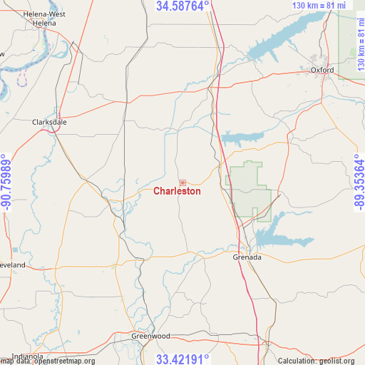
Charleston GPS coordinates[2]
34° 0' 24.408" North, 90° 3' 24.336" West
| Map corner | latitude | longitude |
|---|---|---|
| Upper-left | 34.58764°, | -90.75989° |
| Center: | 34.00678°, | -90.05676° |
| Lower-right: | 33.42191°, | -89.35364° |
| Map W x H: | 129.6×129.6 km | = 80.5×80.5mi |
| max Lat: | 71.29058° ⇑80.2% North |
| Charleston: | 34.00678° |
| min Lat: | ⇓19.8% South 19.06759° |
| min Long | Charleston | max Long |
| -171.73463° | -90.05676° | -66.98998° |
| W 40.8%⇐ | ⇒59.2% E |
Elevation
Elevation of Charleston is 62 m = 203 ft, and this is 232.8 m = 764 ft below average elevation for this country.
| Max E: |
3189 m = 10463 ft | 76.7% |
| Avg. | 294.8 m = 967 ft | |
| Charleston | 62 m = 203 ft | |
Min E: |
-60 m = -197 ft | 23.3% |
See also: United States elevation on elevation.city.
Geographical zone
Charleston is located in North temperate zone (between Tropic of Cancer and the Arctic Circle). Distance of this Northern Tropic circle is 1175.3 km =730.3 mi to South.| Distance of | km | miles | from Charleston |
|---|---|---|---|
| North Pole | 6225.9 | 3868.6 | to North |
| Arctic Circle | 3620 | 2249.4 | to North |
| Tropic Cancer | 1175.3 | 730.3 | to South |
| Equator | 3781.2 | 2349.5 | to South |


Nearby cities:
15 places around Charleston: (largest is in red/bold)
• Batesville
35.4 km =22 mi,  16°
16°
• Coffeeville
35.3 km =21.9 mi,  95°
95°
• Courtland
28.1 km =17.5 mi, 21°
• Crowder
20 km =12.4 mi,  338°
338°
• Elliott
45.8 km =28.5 mi,  141°
141°
• Grenada
35 km =21.7 mi, 139°
• Holcomb
28.3 km =17.6 mi,  164°
164°
• Lambert
30.1 km =18.7 mi,  316°
316°
• Marks
34.2 km =21.3 mi, 324°
• Mikoma
21.9 km =13.6 mi,  253°
253°
• Oakland
14 km =8.7 mi,  67°
67°
• Tutwiler
34.6 km =21.5 mi,  271°
271°
• Walnut
35.3 km =21.9 mi,  296°
296°
• Water Valley
42.3 km =26.3 mi, 67°
• Webb
27.3 km =17 mi,  256°
256°
Sources, notices
• [Note1] Compared only with cities in United States existing in our database
• [Src1] Map data: © OpenStreetMap contributors (CC-BY-SA)
• [Src2] Other city data from geonames.org with taken over terms of usage.
• [Src3] Geographical zone / Annual Mean Temperature by Robert A. Rohde @ Wikipedia
