Como geodata
Como (Mississippi) is a populated place; located in United States in America/Chicago (GMT-5) time zone. With population of 1,245 people, there are 14878 cities with bigger population in this country. Compared to other cities in United States, 77.6% of cities are located further ↑North; 58.8% of cities are located further →East and 68% of cities have higher elevation than Como. Note1


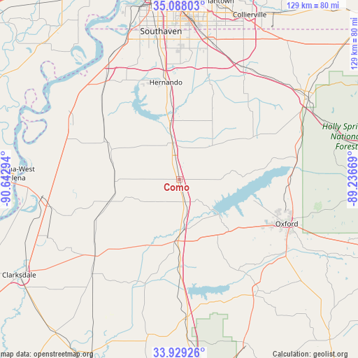
Como GPS coordinates[2]
34° 30' 38.376" North, 89° 56' 23.316" West
| Map corner | latitude | longitude |
|---|---|---|
| Upper-left | 35.08803°, | -90.64294° |
| Center: | 34.51066°, | -89.93981° |
| Lower-right: | 33.92926°, | -89.23669° |
| Map W x H: | 128.8×128.8 km | = 80×80mi |
| max Lat: | 71.29058° ⇑77.6% North |
| Como: | 34.51066° |
| min Lat: | ⇓22.4% South 19.06759° |
| min Long | Como | max Long |
| -171.73463° | -89.93981° | -66.98998° |
| W 41.2%⇐ | ⇒58.8% E |
Elevation
Elevation of Como is 112 m = 367 ft, and this is 182.8 m = 600 ft below average elevation for this country.
| Max E: |
3189 m = 10463 ft | 68% |
| Avg. | 294.8 m = 967 ft | |
| Como | 112 m = 367 ft | |
Min E: |
-60 m = -197 ft | 32% |
See also: United States elevation on elevation.city.
Geographical zone
Como is located in North temperate zone (between Tropic of Cancer and the Arctic Circle). Distance of this Northern Tropic circle is 1231.3 km =765.1 mi to South.| Distance of | km | miles | from Como |
|---|---|---|---|
| North Pole | 6169.8 | 3833.7 | to North |
| Arctic Circle | 3563.9 | 2214.5 | to North |
| Tropic Cancer | 1231.3 | 765.1 | to South |
| Equator | 3837.2 | 2384.3 | to South |


Nearby cities:
15 places around Como: (largest is in red/bold)
• Batesville
22.1 km =13.7 mi,  181°
181°
• Coldwater
20.4 km =12.7 mi,  350°
350°
• Courtland
30 km =18.6 mi, 180°
• Crenshaw
23.7 km =14.7 mi,  267°
267°
• Crowder
41.7 km =25.9 mi,  205°
205°
• Hernando
35.2 km =21.9 mi, 351°
• Marks
41.6 km =25.8 mi,  227°
227°
• North Tunica
45.4 km =28.2 mi,  297°
297°
• Oxford
41.8 km =26 mi,  112°
112°
• Sardis
8.5 km =5.3 mi,  165°
165°
• Senatobia
12.2 km =7.6 mi, 347°
• Sledge
27.2 km =16.9 mi,  251°
251°
• Tunica
44.9 km =27.9 mi, 295°
• University
41.3 km =25.7 mi, 112°
• White Oak
40.8 km =25.4 mi,  291°
291°
Sources, notices
• [Note1] Compared only with cities in United States existing in our database
• [Src1] Map data: © OpenStreetMap contributors (CC-BY-SA)
• [Src2] Other city data from geonames.org with taken over terms of usage.
• [Src3] Geographical zone / Annual Mean Temperature by Robert A. Rohde @ Wikipedia
