Canton geodata
Canton (Mississippi) is a seat of a second-order administrative division; located in United States in America/Chicago (GMT-5) time zone. With population of 13,676 people, there are 3514 cities with bigger population in this country. Compared to other cities in United States, 86.7% of cities are located further ↑North; 59.1% of cities are located further →East and 74.2% of cities have higher elevation than Canton. Note1


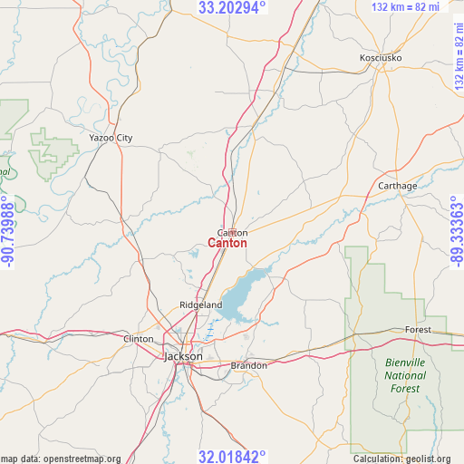
Canton GPS coordinates[2]
32° 36' 45.504" North, 90° 2' 12.3" West
| Map corner | latitude | longitude |
|---|---|---|
| Upper-left | 33.20294°, | -90.73988° |
| Center: | 32.61264°, | -90.03675° |
| Lower-right: | 32.01842°, | -89.33363° |
| Map W x H: | 131.7×131.7 km | = 81.8×81.8mi |
| max Lat: | 71.29058° ⇑86.7% North |
| Canton: | 32.61264° |
| min Lat: | ⇓13.3% South 19.06759° |
| min Long | Canton | max Long |
| -171.73463° | -90.03675° | -66.98998° |
| W 40.9%⇐ | ⇒59.1% E |
Elevation
Elevation of Canton is 76 m = 249 ft, and this is 218.8 m = 718 ft below average elevation for this country.
| Max E: |
3189 m = 10463 ft | 74.2% |
| Avg. | 294.8 m = 967 ft | |
| Canton | 76 m = 249 ft | |
Min E: |
-60 m = -197 ft | 25.8% |
See also: United States elevation on elevation.city.
Geographical zone
Canton is located in North temperate zone (between Tropic of Cancer and the Arctic Circle). Distance of this Northern Tropic circle is 1020.3 km =634 mi to South.| Distance of | km | miles | from Canton |
|---|---|---|---|
| North Pole | 6380.9 | 3964.9 | to North |
| Arctic Circle | 3775 | 2345.7 | to North |
| Tropic Cancer | 1020.3 | 634 | to South |
| Equator | 3626.2 | 2253.2 | to South |


Nearby cities:
15 places around Canton: (largest is in red/bold)
• Brandon
38 km =23.6 mi,  172°
172°
• Clinton
40.3 km =25 mi,  221°
221°
• Flora
26.7 km =16.6 mi,  253°
253°
• Flowood
35 km =21.7 mi,  195°
195°
• Goodman
41.4 km =25.7 mi,  16°
16°
• Jackson
37.6 km =23.4 mi, 201°
• Kearney Park
26.2 km =16.3 mi,  264°
264°
• Madison
18.3 km =11.4 mi, 203°
• Morton
46 km =28.6 mi,  128°
128°
• Pearl
38.6 km =24 mi,  193°
193°
• Pelahatchie
40.1 km =24.9 mi,  146°
146°
• Pickens
30.8 km =19.1 mi,  11°
11°
• Richland
43.1 km =26.8 mi, 195°
• Ridgeland
22.4 km =13.9 mi, 203°
• Yazoo City
43.8 km =27.2 mi,  308°
308°
Sources, notices
• [Note1] Compared only with cities in United States existing in our database
• [Src1] Map data: © OpenStreetMap contributors (CC-BY-SA)
• [Src2] Other city data from geonames.org with taken over terms of usage.
• [Src3] Geographical zone / Annual Mean Temperature by Robert A. Rohde @ Wikipedia
