Pelahatchie geodata
Pelahatchie (Mississippi) is a populated place; located in United States in America/Chicago (GMT-5) time zone. With population of 1,356 people, there are 14319 cities with bigger population in this country. Compared to other cities in United States, 87.8% of cities are located further ↑North; 58.4% of cities are located further →East and 67.7% of cities have higher elevation than Pelahatchie. Note1


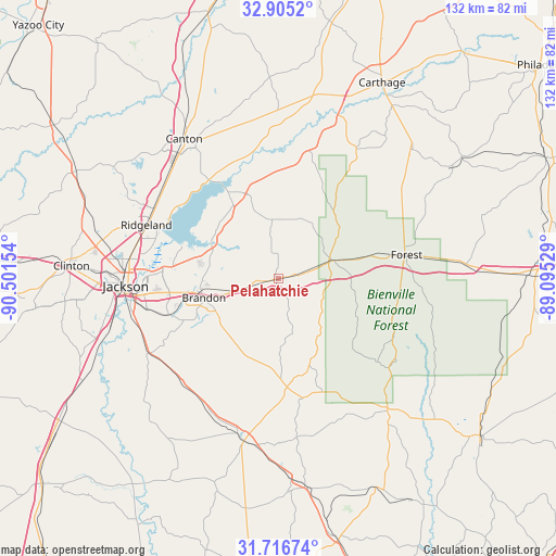
Pelahatchie GPS coordinates[2]
32° 18' 46.512" North, 89° 47' 54.276" West
| Map corner | latitude | longitude |
|---|---|---|
| Upper-left | 32.9052°, | -90.50154° |
| Center: | 32.31292°, | -89.79841° |
| Lower-right: | 31.71674°, | -89.09529° |
| Map W x H: | 132.1×132.1 km | = 82.1×82.1mi |
| max Lat: | 71.29058° ⇑87.8% North |
| Pelahatchie: | 32.31292° |
| min Lat: | ⇓12.2% South 19.06759° |
| min Long | Pelahatchie | max Long |
| -171.73463° | -89.79841° | -66.98998° |
| W 41.6%⇐ | ⇒58.4% E |
Elevation
Elevation of Pelahatchie is 114 m = 374 ft, and this is 180.8 m = 593 ft below average elevation for this country.
| Max E: |
3189 m = 10463 ft | 67.7% |
| Avg. | 294.8 m = 967 ft | |
| Pelahatchie | 114 m = 374 ft | |
Min E: |
-60 m = -197 ft | 32.3% |
See also: United States elevation on elevation.city.
Geographical zone
Pelahatchie is located in North temperate zone (between Tropic of Cancer and the Arctic Circle). Distance of this Northern Tropic circle is 986.9 km =613.2 mi to South.| Distance of | km | miles | from Pelahatchie |
|---|---|---|---|
| North Pole | 6414.2 | 3985.6 | to North |
| Arctic Circle | 3808.3 | 2366.4 | to North |
| Tropic Cancer | 986.9 | 613.2 | to South |
| Equator | 3592.9 | 2232.5 | to South |


Nearby cities:
15 places around Pelahatchie: (largest is in red/bold)
• Brandon
18.2 km =11.3 mi,  255°
255°
• Canton
40.1 km =24.9 mi,  326°
326°
• Cleary
39.5 km =24.5 mi,  245°
245°
• Florence
36 km =22.4 mi,  240°
240°
• Flowood
32 km =19.9 mi,  269°
269°
• Forest
31 km =19.3 mi,  79°
79°
• Hillsboro
31.5 km =19.6 mi,  58°
58°
• Jackson
36.3 km =22.6 mi, 267°
• Madison
34.1 km =21.2 mi,  299°
299°
• Mendenhall
39.6 km =24.6 mi,  189°
189°
• Morton
14.3 km =8.9 mi,  71°
71°
• Pearl
31.6 km =19.6 mi, 262°
• Polkville
16.6 km =10.3 mi,  143°
143°
• Richland
34.8 km =21.6 mi, 256°
• Ridgeland
33.9 km =21.1 mi,  292°
292°
Sources, notices
• [Note1] Compared only with cities in United States existing in our database
• [Src1] Map data: © OpenStreetMap contributors (CC-BY-SA)
• [Src2] Other city data from geonames.org with taken over terms of usage.
• [Src3] Geographical zone / Annual Mean Temperature by Robert A. Rohde @ Wikipedia
