North Tunica geodata
North Tunica (Mississippi) is a populated place; located in United States in America/Chicago (GMT-5) time zone. With population of 1,035 people, there are 16053 cities with bigger population in this country. Compared to other cities in United States, 76.8% of cities are located further ↑North; 60.4% of cities are located further →East and 77.1% of cities have higher elevation than North Tunica. Note1


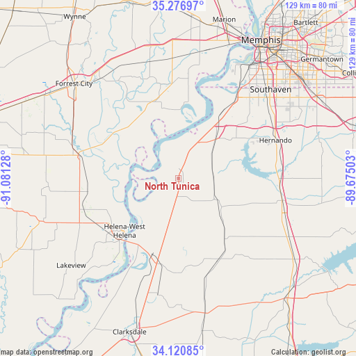
North Tunica GPS coordinates[2]
34° 42' 3.348" North, 90° 22' 41.34" West
| Map corner | latitude | longitude |
|---|---|---|
| Upper-left | 35.27697°, | -91.08128° |
| Center: | 34.70093°, | -90.37815° |
| Lower-right: | 34.12085°, | -89.67503° |
| Map W x H: | 128.5×128.5 km | = 79.8×79.8mi |
| max Lat: | 71.29058° ⇑76.8% North |
| North Tunica: | 34.70093° |
| min Lat: | ⇓23.2% South 19.06759° |
| min Long | North Tunica | max Long |
| -171.73463° | -90.37815° | -66.98998° |
| W 39.6%⇐ | ⇒60.4% E |
Elevation
Elevation of North Tunica is 60 m = 197 ft, and this is 234.8 m = 770 ft below average elevation for this country.
| Max E: |
3189 m = 10463 ft | 77.1% |
| Avg. | 294.8 m = 967 ft | |
| North Tunica | 60 m = 197 ft | |
Min E: |
-60 m = -197 ft | 22.9% |
See also: United States elevation on elevation.city.
Geographical zone
North Tunica is located in North temperate zone (between Tropic of Cancer and the Arctic Circle). Distance of this Northern Tropic circle is 1252.5 km =778.3 mi to South.| Distance of | km | miles | from North Tunica |
|---|---|---|---|
| North Pole | 6148.7 | 3820.6 | to North |
| Arctic Circle | 3542.8 | 2201.4 | to North |
| Tropic Cancer | 1252.5 | 778.3 | to South |
| Equator | 3858.4 | 2397.5 | to South |


Nearby cities:
15 places around North Tunica: (largest is in red/bold)
• Coldwater
36.7 km =22.8 mi,  91°
91°
• Crenshaw
27.5 km =17.1 mi,  143°
143°
• Helena
27.3 km =17 mi,  225°
225°
• Helena-West Helena
27.2 km =16.9 mi, 225°
• Hernando
37.7 km =23.4 mi,  68°
68°
• Hughes
28.9 km =18 mi,  342°
342°
• Lynchburg
38.8 km =24.1 mi,  41°
41°
• Marianna
35.6 km =22.1 mi,  283°
283°
• Senatobia
38.6 km =24 mi,  103°
103°
• Sledge
33.2 km =20.6 mi,  154°
154°
• Tunica
1.9 km =1.2 mi,  193°
193°
• Tunica Resorts
15.3 km =9.5 mi,  10°
10°
• Walls
35.2 km =21.9 mi, 35°
• West Helena
29.3 km =18.2 mi,  235°
235°
• White Oak
6.5 km =4 mi,  160°
160°
Sources, notices
• [Note1] Compared only with cities in United States existing in our database
• [Src1] Map data: © OpenStreetMap contributors (CC-BY-SA)
• [Src2] Other city data from geonames.org with taken over terms of usage.
• [Src3] Geographical zone / Annual Mean Temperature by Robert A. Rohde @ Wikipedia
