Hughes geodata
Hughes (Arkansas) is a populated place; located in United States in America/Chicago (GMT-5) time zone. With population of 1,323 people, there are 14471 cities with bigger population in this country. Compared to other cities in United States, 75.7% of cities are located further ↑North; 60.8% of cities are located further →East and 76.5% of cities have higher elevation than Hughes. Note1
Administrative division(s):
- Level 1: Arkansas
- Level 2: Saint Francis County
- Level 3: Township of Garland


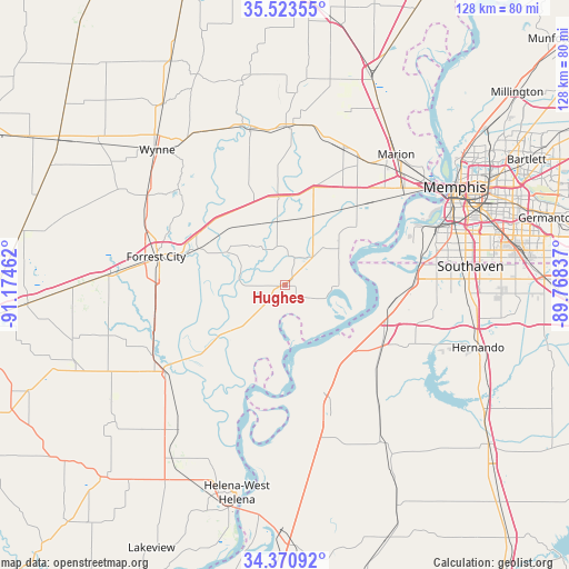
Hughes GPS coordinates[2]
34° 56' 57.336" North, 90° 28' 17.364" West
| Map corner | latitude | longitude |
|---|---|---|
| Upper-left | 35.52355°, | -91.17462° |
| Center: | 34.94926°, | -90.47149° |
| Lower-right: | 34.37092°, | -89.76837° |
| Map W x H: | 128.2×128.2 km | = 79.7×79.7mi |
| max Lat: | 71.29058° ⇑75.7% North |
| Hughes: | 34.94926° |
| min Lat: | ⇓24.3% South 19.06759° |
| min Long | Hughes | max Long |
| -171.73463° | -90.47149° | -66.98998° |
| W 39.2%⇐ | ⇒60.8% E |
Elevation
Elevation of Hughes is 63 m = 207 ft, and this is 231.8 m = 760 ft below average elevation for this country.
| Max E: |
3189 m = 10463 ft | 76.5% |
| Avg. | 294.8 m = 967 ft | |
| Hughes | 63 m = 207 ft | |
Min E: |
-60 m = -197 ft | 23.5% |
See also: United States elevation on elevation.city.
Geographical zone
Hughes is located in North temperate zone (between Tropic of Cancer and the Arctic Circle). Distance of this Northern Tropic circle is 1280.1 km =795.4 mi to South.| Distance of | km | miles | from Hughes |
|---|---|---|---|
| North Pole | 6121.1 | 3803.5 | to North |
| Arctic Circle | 3515.2 | 2184.2 | to North |
| Tropic Cancer | 1280.1 | 795.4 | to South |
| Equator | 3886 | 2414.6 | to South |


Nearby cities:
15 places around Hughes: (largest is in red/bold)
• Earle
36.2 km =22.5 mi,  0°
0°
• Forrest City
29.7 km =18.5 mi,  282°
282°
• Horn Lake
39.8 km =24.7 mi,  89°
89°
• Lynchburg
34.3 km =21.3 mi, 87°
• Madison
24 km =14.9 mi,  287°
287°
• Marianna
32.6 km =20.3 mi,  233°
233°
• Marion
38.7 km =24 mi,  40°
40°
• North Tunica
28.9 km =18 mi,  162°
162°
• Palestine
39.4 km =24.5 mi,  273°
273°
• Parkin
36.1 km =22.4 mi,  345°
345°
• Tunica
30.5 km =19 mi, 164°
• Tunica Resorts
16.9 km =10.5 mi,  137°
137°
• Walls
29.1 km =18.1 mi, 88°
• West Memphis
34.1 km =21.2 mi,  49°
49°
• White Oak
35.4 km =22 mi, 162°
Sources, notices
• [Note1] Compared only with cities in United States existing in our database
• [Src1] Map data: © OpenStreetMap contributors (CC-BY-SA)
• [Src2] Other city data from geonames.org with taken over terms of usage.
• [Src3] Geographical zone / Annual Mean Temperature by Robert A. Rohde @ Wikipedia
