Walls geodata
Walls (Mississippi) is a populated place; located in United States in America/Chicago (GMT-5) time zone. With population of 1,268 people, there are 14743 cities with bigger population in this country. Compared to other cities in United States, 75.6% of cities are located further ↑North; 59.4% of cities are located further →East and 75.8% of cities have higher elevation than Walls. Note1


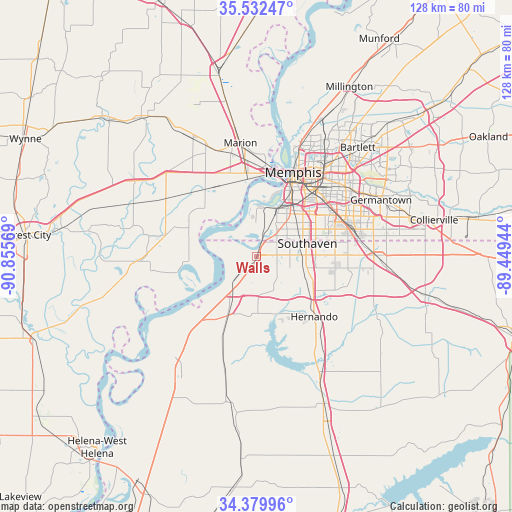
Walls GPS coordinates[2]
34° 57' 29.664" North, 90° 9' 9.216" West
| Map corner | latitude | longitude |
|---|---|---|
| Upper-left | 35.53247°, | -90.85569° |
| Center: | 34.95824°, | -90.15256° |
| Lower-right: | 34.37996°, | -89.44944° |
| Map W x H: | 128.1×128.1 km | = 79.6×79.6mi |
| max Lat: | 71.29058° ⇑75.6% North |
| Walls: | 34.95824° |
| min Lat: | ⇓24.4% South 19.06759° |
| min Long | Walls | max Long |
| -171.73463° | -90.15256° | -66.98998° |
| W 40.6%⇐ | ⇒59.4% E |
Elevation
Elevation of Walls is 67 m = 220 ft, and this is 227.8 m = 747 ft below average elevation for this country.
| Max E: |
3189 m = 10463 ft | 75.8% |
| Avg. | 294.8 m = 967 ft | |
| Walls | 67 m = 220 ft | |
Min E: |
-60 m = -197 ft | 24.2% |
See also: United States elevation on elevation.city.
Geographical zone
Walls is located in North temperate zone (between Tropic of Cancer and the Arctic Circle). Distance of this Northern Tropic circle is 1281.1 km =796 mi to South.| Distance of | km | miles | from Walls |
|---|---|---|---|
| North Pole | 6120.1 | 3802.9 | to North |
| Arctic Circle | 3514.2 | 2183.6 | to North |
| Tropic Cancer | 1281.1 | 796 | to South |
| Equator | 3887 | 2415.3 | to South |


Nearby cities:
15 places around Walls: (largest is in red/bold)
• Coldwater
33.7 km =20.9 mi,  151°
151°
• Germantown
34.3 km =21.3 mi,  65°
65°
• Hernando
20.8 km =12.9 mi,  135°
135°
• Horn Lake
10.7 km =6.6 mi,  91°
91°
• Hughes
29.1 km =18.1 mi,  268°
268°
• Lynchburg
5.2 km =3.2 mi,  84°
84°
• Marion
28.8 km =17.9 mi,  352°
352°
• Memphis
23.3 km =14.5 mi,  23°
23°
• New South Memphis
16.7 km =10.4 mi,  31°
31°
• North Tunica
35.2 km =21.9 mi,  215°
215°
• Olive Branch
29.4 km =18.3 mi, 89°
• Southaven
13.2 km =8.2 mi, 74°
• Tunica
37 km =23 mi,  214°
214°
• Tunica Resorts
22.3 km =13.9 mi,  232°
232°
• West Memphis
21.1 km =13.1 mi, 352°
Sources, notices
• [Note1] Compared only with cities in United States existing in our database
• [Src1] Map data: © OpenStreetMap contributors (CC-BY-SA)
• [Src2] Other city data from geonames.org with taken over terms of usage.
• [Src3] Geographical zone / Annual Mean Temperature by Robert A. Rohde @ Wikipedia
