Apex geodata
Apex (North Carolina) is a populated place; located in United States in America/New_York (GMT-4) time zone. With population of 45,585 people, there are 1050 cities with bigger population in this country. Compared to other cities in United States, 71.6% of cities are located further ↑North; 76.1% of cities are located further ←West and 60.3% of cities have higher elevation than Apex. Note1
Administrative division(s):
- Level 1: North Carolina
- Level 2: Wake County
- Level 3: Township of White Oak


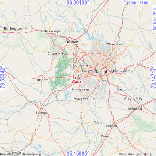
Apex GPS coordinates[2]
35° 43' 57.54" North, 78° 51' 1.044" West
| Map corner | latitude | longitude |
|---|---|---|
| Upper-left | 36.30136°, | -79.55342° |
| Center: | 35.73265°, | -78.85029° |
| Lower-right: | 35.15985°, | -78.14717° |
| Map W x H: | 126.9×126.9 km | = 78.9×78.9mi |
| max Lat: | 71.29058° ⇑71.6% North |
| Apex: | 35.73265° |
| min Lat: | ⇓28.4% South 19.06759° |
| min Long | Apex | max Long |
| -171.73463° | -78.85029° | -66.98998° |
| W 76.1%⇐ | ⇒23.9% E |
Elevation
Elevation of Apex is 153 m = 502 ft, and this is 141.8 m = 465 ft below average elevation for this country.
| Max E: |
3189 m = 10463 ft | 60.3% |
| Avg. | 294.8 m = 967 ft | |
| Apex | 153 m = 502 ft | |
Min E: |
-60 m = -197 ft | 39.7% |
See also: Apex elevation on elevation.city.
Geographical zone
Apex is located in North temperate zone (between Tropic of Cancer and the Arctic Circle). Distance of this Northern Tropic circle is 1367.2 km =849.5 mi to South.| Distance of | km | miles | from Apex |
|---|---|---|---|
| North Pole | 6034 | 3749.4 | to North |
| Arctic Circle | 3428.1 | 2130.1 | to North |
| Tropic Cancer | 1367.2 | 849.5 | to South |
| Equator | 3973.1 | 2468.8 | to South |


Nearby cities:
15 places around Apex: (largest is in red/bold)
• Angier
27 km =16.8 mi,  158°
158°
• Carrboro
28.3 km =17.6 mi,  314°
314°
• Cary
9 km =5.6 mi,  43°
43°
• Chapel Hill
27.3 km =17 mi,  317°
317°
• Fearrington
21.7 km =13.5 mi,  292°
292°
• Fearrington Village
23.1 km =14.4 mi, 290°
• Fuquay-Varina
17.1 km =10.6 mi, 164°
• Garner
21.4 km =13.3 mi,  96°
96°
• Green Level
7.3 km =4.5 mi, 318°
• Holly Springs
9.2 km =5.7 mi,  170°
170°
• Moncure
24 km =14.9 mi,  239°
239°
• Morrisville
10.3 km =6.4 mi,  12°
12°
• Raleigh
19.6 km =12.2 mi,  77°
77°
• Scotts Mill
3.1 km =1.9 mi,  257°
257°
• West Raleigh
17.9 km =11.1 mi,  70°
70°
Sources, notices
• [Note1] Compared only with cities in United States existing in our database
• [Src1] Map data: © OpenStreetMap contributors (CC-BY-SA)
• [Src2] Other city data from geonames.org with taken over terms of usage.
• [Src3] Geographical zone / Annual Mean Temperature by Robert A. Rohde @ Wikipedia
