Cary geodata
Cary (North Carolina) is a populated place; located in United States in America/New_York (GMT-4) time zone. With population of 159,769 people, there are 177 cities with bigger population in this country. Compared to other cities in United States, 71.4% of cities are located further ↑North; 76.4% of cities are located further ←West and 60.5% of cities have higher elevation than Cary. Note1


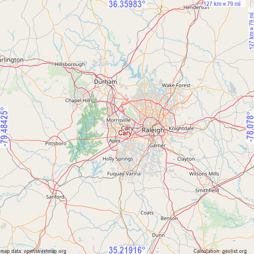
Cary GPS coordinates[2]
35° 47' 29.544" North, 78° 46' 52.032" West
| Map corner | latitude | longitude |
|---|---|---|
| Upper-left | 36.35983°, | -79.48425° |
| Center: | 35.79154°, | -78.78112° |
| Lower-right: | 35.21916°, | -78.078° |
| Map W x H: | 126.8×126.8 km | = 78.8×78.8mi |
| max Lat: | 71.29058° ⇑71.4% North |
| Cary: | 35.79154° |
| min Lat: | ⇓28.6% South 19.06759° |
| min Long | Cary | max Long |
| -171.73463° | -78.78112° | -66.98998° |
| W 76.4%⇐ | ⇒23.6% E |
Elevation
Elevation of Cary is 152 m = 499 ft, and this is 142.8 m = 469 ft below average elevation for this country.
| Max E: |
3189 m = 10463 ft | 60.5% |
| Avg. | 294.8 m = 967 ft | |
| Cary | 152 m = 499 ft | |
Min E: |
-60 m = -197 ft | 39.5% |
See also: Cary elevation on elevation.city.
Geographical zone
Cary is located in North temperate zone (between Tropic of Cancer and the Arctic Circle). Distance of this Northern Tropic circle is 1373.7 km =853.6 mi to South.| Distance of | km | miles | from Cary |
|---|---|---|---|
| North Pole | 6027.4 | 3745.3 | to North |
| Arctic Circle | 3421.5 | 2126 | to North |
| Tropic Cancer | 1373.7 | 853.6 | to South |
| Equator | 3979.6 | 2472.8 | to South |


Nearby cities:
15 places around Cary: (largest is in red/bold)
• Apex
9 km =5.6 mi,  223°
223°
• Chapel Hill
28.2 km =17.5 mi,  298°
298°
• Durham
24.9 km =15.5 mi,  334°
334°
• Fearrington
26.4 km =16.4 mi,  273°
273°
• Fearrington Village
27.9 km =17.3 mi, 272°
• Fuquay-Varina
23.1 km =14.4 mi,  184°
184°
• Garner
17.5 km =10.9 mi,  120°
120°
• Gorman
27.5 km =17.1 mi,  352°
352°
• Green Level
11.1 km =6.9 mi,  264°
264°
• Holly Springs
16.3 km =10.1 mi,  196°
196°
• Knightdale
27.1 km =16.8 mi,  90°
90°
• Morrisville
5.4 km =3.4 mi,  311°
311°
• Raleigh
13 km =8.1 mi,  99°
99°
• Scotts Mill
11.7 km =7.3 mi,  232°
232°
• West Raleigh
10.6 km =6.6 mi, 92°
Sources, notices
• [Note1] Compared only with cities in United States existing in our database
• [Src1] Map data: © OpenStreetMap contributors (CC-BY-SA)
• [Src2] Other city data from geonames.org with taken over terms of usage.
• [Src3] Geographical zone / Annual Mean Temperature by Robert A. Rohde @ Wikipedia
