Raleigh geodata
Raleigh (North Carolina) is a seat of a first-order administrative division; located in United States in America/New_York (GMT-4) time zone. With population of 451,066 people, there are 47 cities with bigger population in this country. Compared to other cities in United States, 71.5% of cities are located further ↑North; 76.7% of cities are located further ←West and 70.3% of cities have higher elevation than Raleigh. Note1
Administrative division(s):
- Level 1: North Carolina
- Level 2: Wake County
- Level 3: Township of Raleigh


Raleigh GPS coordinates[2]
35° 46' 19.56" North, 78° 38' 18.996" West
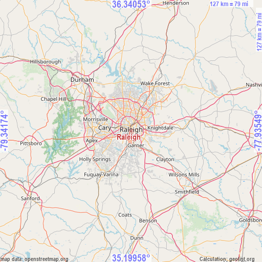
| Map corner | latitude | longitude |
|---|---|---|
| Upper-left | 36.34053°, | -79.34174° |
| Center: | 35.7721°, | -78.63861° |
| Lower-right: | 35.19958°, | -77.93549° |
| Map W x H: | 126.9×126.9 km | = 78.9×78.9mi |
| max Lat: | 71.29058° ⇑71.5% North |
| Raleigh: | 35.7721° |
| min Lat: | ⇓28.5% South 19.06759° |
| min Long | Raleigh | max Long |
| -171.73463° | -78.63861° | -66.98998° |
| W 76.7%⇐ | ⇒23.3% E |
Elevation
Elevation of Raleigh is 99 m = 325 ft, and this is 195.8 m = 642 ft below average elevation for this country.
| Max E: |
3189 m = 10463 ft | 70.3% |
| Avg. | 294.8 m = 967 ft | |
| Raleigh | 99 m = 325 ft | |
Min E: |
-60 m = -197 ft | 29.7% |
See also: Raleigh elevation on elevation.city.
Geographical zone
Raleigh is located in North temperate zone (between Tropic of Cancer and the Arctic Circle). Distance of this Northern Tropic circle is 1371.6 km =852.3 mi to South.| Distance of | km | miles | from Raleigh |
|---|---|---|---|
| North Pole | 6029.6 | 3746.6 | to North |
| Arctic Circle | 3423.7 | 2127.4 | to North |
| Tropic Cancer | 1371.6 | 852.3 | to South |
| Equator | 3977.5 | 2471.5 | to South |


Nearby cities:
15 places around Raleigh: (largest is in red/bold)
• Apex
19.6 km =12.2 mi,  257°
257°
• Archer Lodge
25.3 km =15.7 mi,  110°
110°
• Cary
13 km =8.1 mi,  279°
279°
• Clayton
21.3 km =13.2 mi,  129°
129°
• Fuquay-Varina
25.5 km =15.8 mi,  214°
214°
• Garner
7.1 km =4.4 mi,  161°
161°
• Green Level
24 km =14.9 mi,  272°
272°
• Holly Springs
22.1 km =13.7 mi,  232°
232°
• Knightdale
14.4 km =8.9 mi,  83°
83°
• Morrisville
17.8 km =11.1 mi,  288°
288°
• Rolesville
23.4 km =14.5 mi,  44°
44°
• Scotts Mill
22.7 km =14.1 mi, 257°
• Wake Forest
25.9 km =16.1 mi,  26°
26°
• Wendell
24.3 km =15.1 mi,  87°
87°
• West Raleigh
2.8 km =1.7 mi,  305°
305°
Sources, notices
• [Note1] Compared only with cities in United States existing in our database
• [Src1] Map data: © OpenStreetMap contributors (CC-BY-SA)
• [Src2] Other city data from geonames.org with taken over terms of usage.
• [Src3] Geographical zone / Annual Mean Temperature by Robert A. Rohde @ Wikipedia
