Scotts Mill geodata
Scotts Mill (North Carolina) is a section of populated place; located in United States in America/New_York (GMT-4) time zone. With population of 2,400 people, there are 10850 cities with bigger population in this country. Compared to other cities in United States, 71.7% of cities are located further ↑North; 76% of cities are located further ←West and 69.1% of cities have higher elevation than Scotts Mill. Note1
Administrative division(s):
- Level 1: North Carolina
- Level 2: Wake County
- Level 3: Township of White Oak


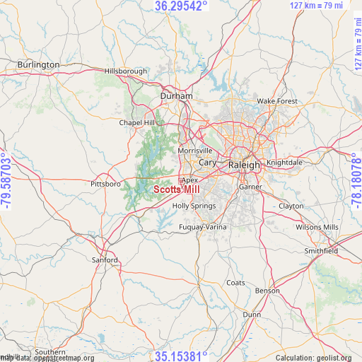
Scotts Mill GPS coordinates[2]
35° 43' 35.976" North, 78° 53' 2.04" West
| Map corner | latitude | longitude |
|---|---|---|
| Upper-left | 36.29542°, | -79.58703° |
| Center: | 35.72666°, | -78.8839° |
| Lower-right: | 35.15381°, | -78.18078° |
| Map W x H: | 126.9×126.9 km | = 78.9×78.9mi |
| max Lat: | 71.29058° ⇑71.7% North |
| Scotts Mill: | 35.72666° |
| min Lat: | ⇓28.3% South 19.06759° |
| min Long | Scotts Mill | max Long |
| -171.73463° | -78.8839° | -66.98998° |
| W 76%⇐ | ⇒24% E |
Elevation
Elevation of Scotts Mill is 106 m = 348 ft, and this is 188.8 m = 619 ft below average elevation for this country.
| Max E: |
3189 m = 10463 ft | 69.1% |
| Avg. | 294.8 m = 967 ft | |
| Scotts Mill | 106 m = 348 ft | |
Min E: |
-60 m = -197 ft | 30.9% |
See also: United States elevation on elevation.city.
Geographical zone
Scotts Mill is located in North temperate zone (between Tropic of Cancer and the Arctic Circle). Distance of this Northern Tropic circle is 1366.5 km =849.1 mi to South.| Distance of | km | miles | from Scotts Mill |
|---|---|---|---|
| North Pole | 6034.6 | 3749.7 | to North |
| Arctic Circle | 3428.7 | 2130.5 | to North |
| Tropic Cancer | 1366.5 | 849.1 | to South |
| Equator | 3972.4 | 2468.3 | to South |


Nearby cities:
15 places around Scotts Mill: (largest is in red/bold)
• Apex
3.1 km =1.9 mi,  77°
77°
• Carrboro
26.7 km =16.6 mi,  319°
319°
• Cary
11.7 km =7.3 mi,  52°
52°
• Chapel Hill
25.9 km =16.1 mi, 323°
• Fearrington
19.3 km =12 mi,  297°
297°
• Fearrington Village
20.5 km =12.7 mi,  294°
294°
• Fuquay-Varina
17.5 km =10.9 mi,  154°
154°
• Garner
24.4 km =15.2 mi,  94°
94°
• Green Level
6.4 km =4 mi,  343°
343°
• Holly Springs
9.5 km =5.9 mi, 151°
• Moncure
21 km =13 mi,  236°
236°
• Morrisville
12 km =7.5 mi,  26°
26°
• Pittsboro
26.5 km =16.5 mi,  268°
268°
• Raleigh
22.7 km =14.1 mi, 77°
• West Raleigh
20.9 km =13 mi,  71°
71°
Sources, notices
• [Note1] Compared only with cities in United States existing in our database
• [Src1] Map data: © OpenStreetMap contributors (CC-BY-SA)
• [Src2] Other city data from geonames.org with taken over terms of usage.
• [Src3] Geographical zone / Annual Mean Temperature by Robert A. Rohde @ Wikipedia
