Bessemer City geodata
Bessemer City (North Carolina) is a populated place; located in United States in America/New_York (GMT-4) time zone. With population of 5,548 people, there are 6723 cities with bigger population in this country. Compared to other cities in United States, 73.7% of cities are located further ↑North; 68.6% of cities are located further ←West and 68.5% of cities have lower elevation than Bessemer City. Note1
Administrative division(s):
- Level 1: North Carolina
- Level 2: Gaston County
- Level 3: Township of Crowders Mountain


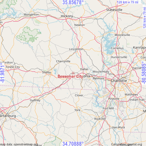
Bessemer City GPS coordinates[2]
35° 17' 5.496" North, 81° 17' 2.292" West
| Map corner | latitude | longitude |
|---|---|---|
| Upper-left | 35.85678°, | -81.9871° |
| Center: | 35.28486°, | -81.28397° |
| Lower-right: | 34.70888°, | -80.58085° |
| Map W x H: | 127.6×127.6 km | = 79.3×79.3mi |
| max Lat: | 71.29058° ⇑73.7% North |
| Bessemer City: | 35.28486° |
| min Lat: | ⇓26.3% South 19.06759° |
| min Long | Bessemer City | max Long |
| -171.73463° | -81.28397° | -66.98998° |
| W 68.6%⇐ | ⇒31.4% E |
Elevation
Elevation of Bessemer City is 278 m = 912 ft, and this is 16.8 m = 55 ft below average elevation for this country.
| Max E: |
3189 m = 10463 ft | 31.5% |
| Avg. | 294.8 m = 967 ft | |
| Bessemer City | 278 m = 912 ft | |
Min E: |
-60 m = -197 ft | 68.5% |
See also: United States elevation on elevation.city.
Geographical zone
Bessemer City is located in North temperate zone (between Tropic of Cancer and the Arctic Circle). Distance of this Northern Tropic circle is 1317.4 km =818.6 mi to South.| Distance of | km | miles | from Bessemer City |
|---|---|---|---|
| North Pole | 6083.8 | 3780.3 | to North |
| Arctic Circle | 3477.9 | 2161.1 | to North |
| Tropic Cancer | 1317.4 | 818.6 | to South |
| Equator | 3923.3 | 2437.8 | to South |


Nearby cities:
15 places around Bessemer City: (largest is in red/bold)
• Cherryville
13.5 km =8.4 mi,  320°
320°
• Cramerton
19.6 km =12.2 mi,  105°
105°
• Dallas
10.4 km =6.5 mi,  70°
70°
• Gastonia
9.1 km =5.7 mi, 106°
• Grover
19.4 km =12.1 mi,  230°
230°
• High Shoals
15 km =9.3 mi,  29°
29°
• Kings Mountain
6.8 km =4.2 mi, 229°
• Light Oak
17.5 km =10.9 mi,  269°
269°
• Lowell
16.5 km =10.3 mi,  96°
96°
• McAdenville
19.1 km =11.9 mi, 98°
• Ranlo
13.9 km =8.6 mi,  89°
89°
• South Gastonia
10.2 km =6.3 mi,  135°
135°
• Stanley
18.9 km =11.7 mi,  64°
64°
• Tryon
7 km =4.3 mi,  330°
330°
• White Plains
11.8 km =7.3 mi,  241°
241°
Sources, notices
• [Note1] Compared only with cities in United States existing in our database
• [Src1] Map data: © OpenStreetMap contributors (CC-BY-SA)
• [Src2] Other city data from geonames.org with taken over terms of usage.
• [Src3] Geographical zone / Annual Mean Temperature by Robert A. Rohde @ Wikipedia
