Gastonia geodata
Gastonia (North Carolina) is a seat of a second-order administrative division; located in United States in America/New_York (GMT-4) time zone. With population of 74,543 people, there are 545 cities with bigger population in this country. Compared to other cities in United States, 73.9% of cities are located further ↑North; 68.9% of cities are located further ←West and 62.1% of cities have lower elevation than Gastonia. Note1
Administrative division(s):
- Level 1: North Carolina
- Level 2: Gaston County
- Level 3: Township of Gastonia


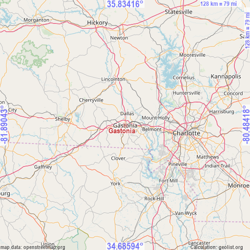
Gastonia GPS coordinates[2]
35° 15' 43.488" North, 81° 11' 14.28" West
| Map corner | latitude | longitude |
|---|---|---|
| Upper-left | 35.83416°, | -81.89043° |
| Center: | 35.26208°, | -81.1873° |
| Lower-right: | 34.68594°, | -80.48418° |
| Map W x H: | 127.7×127.7 km | = 79.3×79.3mi |
| max Lat: | 71.29058° ⇑73.9% North |
| Gastonia: | 35.26208° |
| min Lat: | ⇓26.1% South 19.06759° |
| min Long | Gastonia | max Long |
| -171.73463° | -81.1873° | -66.98998° |
| W 68.9%⇐ | ⇒31.1% E |
Elevation
Elevation of Gastonia is 249 m = 817 ft, and this is 45.8 m = 150 ft below average elevation for this country.
| Max E: |
3189 m = 10463 ft | 37.9% |
| Avg. | 294.8 m = 967 ft | |
| Gastonia | 249 m = 817 ft | |
Min E: |
-60 m = -197 ft | 62.1% |
See also: Gastonia elevation on elevation.city.
Geographical zone
Gastonia is located in North temperate zone (between Tropic of Cancer and the Arctic Circle). Distance of this Northern Tropic circle is 1314.9 km =817 mi to South.| Distance of | km | miles | from Gastonia |
|---|---|---|---|
| North Pole | 6086.3 | 3781.9 | to North |
| Arctic Circle | 3480.4 | 2162.6 | to North |
| Tropic Cancer | 1314.9 | 817 | to South |
| Equator | 3920.8 | 2436.3 | to South |


Nearby cities:
15 places around Gastonia: (largest is in red/bold)
• Belmont
13.8 km =8.6 mi,  98°
98°
• Bessemer City
9.1 km =5.7 mi,  286°
286°
• Clover
17.1 km =10.6 mi,  191°
191°
• Cramerton
10.5 km =6.5 mi, 104°
• Dallas
6.1 km =3.8 mi,  9°
9°
• High Shoals
15.7 km =9.8 mi,  355°
355°
• Kings Mountain
14.1 km =8.8 mi,  262°
262°
• Lowell
7.7 km =4.8 mi,  85°
85°
• McAdenville
10.2 km =6.3 mi, 91°
• Mount Holly
16.1 km =10 mi,  75°
75°
• Ranlo
5.8 km =3.6 mi,  62°
62°
• South Gastonia
5 km =3.1 mi,  199°
199°
• Stanley
13.5 km =8.4 mi,  37°
37°
• Tryon
15 km =9.3 mi,  305°
305°
• White Plains
19.4 km =12.1 mi, 260°
Sources, notices
• [Note1] Compared only with cities in United States existing in our database
• [Src1] Map data: © OpenStreetMap contributors (CC-BY-SA)
• [Src2] Other city data from geonames.org with taken over terms of usage.
• [Src3] Geographical zone / Annual Mean Temperature by Robert A. Rohde @ Wikipedia
